Home
Weather New York
WeatherRadar
RainRadar
TemperatureRadar
WindRadar
LightningRadar
Weather News
Editor's Pick
Discover the app
Weather widget
Contact us
Apps
Career
    Home / Editor's Pick /

    Ash clouds and lava flows: Guatemala's Fuego Volcano erupts

09:00 PM
May 5, 2023

Ash clouds and lava flows
Guatemala's Fuego Volcano erupts

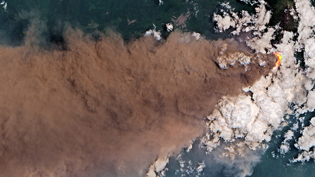
Fuego Satellitenbild
The Fuego volcano in Guatemala erupted violently on Thursday this week. - © Sentinel 2 - ESA/Copernicus

Guatemala’s Fuego volcano erupted on Thursday, with fountains of lava shooting over 1,500 feet into the sky.

The eruption formed an ash cloud up to 37 miles high and more than 125 miles long, in addition to lava and pyroclastic flows.

These are streams of hot ash, volcanic gases, and rock fragments that move rapidly downhill on the flanks of a volcano.

Privacy policy

In nearby towns such as Morelia and Panimaché, more than 1000 people were evacuated as a precaution, according to authorities. Ashfall was recorded in numerous municipalities.

The National Institute of Seismology, Volcanology, Meteorology, and Hydrology (INSIVUMEH) also warned of possible mud and debris avalanches due to expected rainfall on the day.

Volcán de Fuego, Fire Volcano, is notorious for its dangerous eruptions. A major eruption of the 2.25-mile-high volcano in the south of the Central American country previously left hundreds dead and missing in 2018.

This marked the most powerful eruption since 1974 with pyroclastic flows reaching multiple villages.

Guatemala has 37 volcanoes across its land with three, Fuego, Pacaya, and Santiaguito, seeing constant activity throughout the year.

Located at the meeting point of the North American and Caribbean tectonic plates, the country hosts many mountains and commonly sees earthquakes due to the constant movement between plates.

Weather & Radar USA editorial team
More on the topic
Super Typhoon Near the Philippines. Gusts up to 155. . . Tuesday, June 23, 2026
Tuesday, June 23, 2026

Gusts up to 155

Super Typhoon Near the Philippines
High pressure & extreme heat. Why & how does it work?. . . Sunday, July 12, 2026
Sunday, July 12, 2026

Why & how does it work?

High pressure & extreme heat
Super Typhoon Bavi threatens Taiwan. 155 mph winds. . Weather Videos. Wednesday, July 8, 2026
The image shows an intense tropical cyclone over the western Pacific, east of Taiwan and the Philippines. The centre of the system is depicted as a light purple and white vortex with a clearly visible eye, surrounded by a ring of red and orange areas indicating the strongest wind speeds. A white arrow marks the typhoon’s predicted track towards the north-west, in the direction of Taiwan. To the west of the storm lie the Philippines, with the cities of Manila and Cebu; to the north of these lies Taiwan, with Taipei. Further west, the Chinese coast, including Hong Kong, and parts of Vietnam can be seen. The coloured wind map shows predominantly green areas outside the storm’s core, indicating significantly weaker winds. White streamlines illustrate the typhoon’s anti-clockwise circulation in the Northern Hemisphere. The highest wind speeds are concentrated around the eye of the cyclone.
Weather VideosWednesday, July 8, 2026

155 mph winds

Super Typhoon Bavi threatens Taiwan
All weather news
This might also interest you
Southwest heat disrupts daily flow. Closures & delays. . . Monday, July 27, 2026
Monday, July 27, 2026

Closures & delays

Southwest heat disrupts daily flow
Heat indices soaring. High humidity. . . Saturday, July 25, 2026
Saturday, July 25, 2026

High humidity

Heat indices soaring
Multi-Day flood threat for Mid-Atlantic. Stalled front. . . Wednesday, July 22, 2026
Wednesday, July 22, 2026

Stalled front

Multi-Day flood threat for Mid-Atlantic
All articles
Weather & Radar

Weather & Radar is also available on

Google Play StoreApp Store

Company

Contact us Privacy policy Legal info Accessibility statement

Services

Uploader

Socials

instagramfacebookthreadslinkList