Home
Weather New York
WeatherRadar
RainRadar
TemperatureRadar
WindRadar
LightningRadar
Weather News
Editor's Pick
Discover the app
Weather widget
Contact us
Apps
Career
    Home / Weather News /

    Avoid burns - This Spring: Check the UV index

09:00 AM
March 29, 2026

Avoid burns
This Spring: Check the UV index

As temperatures rise and days grow sunnier, many spend more time outdoors. However, longer and hotter days increase our exposure to ultraviolet (UV) radiation, a key factor in skin cancer.

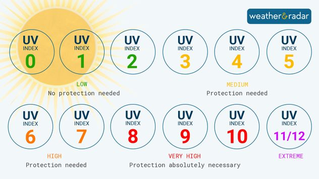
If you and your family are planning to spend time outdoors this spring, check the UV index to prevent burns.

There are three types of UV rays: UVA, UVB, and UVC. UVC is absorbed by the atmosphere before reaching the Earth. UVB affects the skin's surface and can cause sunburn, while UVA, present throughout the year, penetrates deeper into the skin, contributing to aging and an elevated risk of skin cancer.

The UV Index.

Our UV forecast can help you determine how much sunscreen you need. A higher UV Index indicates stronger UV radiation and a quicker potential for skin damage. During high UV days, burning can occur within 30-60 minutes.

Avoid the midday sun, wear protective clothing, and regularly apply sunscreen with an SPF of 30+ to prevent sunburn and skin damage. Check your local UV forecast on the Weather & Radar app to stay informed about potential dangers. Our app offers a four-day UV forecast detailing how UV levels fluctuate throughout the day.

Mary Mays
More on the topic
How does fog form?. Multiple ways. . . Saturday, July 11, 2026
Saturday, July 11, 2026

Multiple ways

How does fog form?
Europe: Warmest June on record. Warm waters too. . . Friday, July 10, 2026
The record-breaking heatwave in June has made climate history in Western Europe.
Friday, July 10, 2026

Warm waters too

Europe: Warmest June on record
Super Typhoon Bavi threatens Taiwan. 155 mph winds. . Weather Videos. Wednesday, July 8, 2026
The image shows an intense tropical cyclone over the western Pacific, east of Taiwan and the Philippines. The centre of the system is depicted as a light purple and white vortex with a clearly visible eye, surrounded by a ring of red and orange areas indicating the strongest wind speeds. A white arrow marks the typhoon’s predicted track towards the north-west, in the direction of Taiwan. To the west of the storm lie the Philippines, with the cities of Manila and Cebu; to the north of these lies Taiwan, with Taipei. Further west, the Chinese coast, including Hong Kong, and parts of Vietnam can be seen. The coloured wind map shows predominantly green areas outside the storm’s core, indicating significantly weaker winds. White streamlines illustrate the typhoon’s anti-clockwise circulation in the Northern Hemisphere. The highest wind speeds are concentrated around the eye of the cyclone.
Weather VideosWednesday, July 8, 2026

155 mph winds

Super Typhoon Bavi threatens Taiwan
All weather news
This might also interest you
Moisture surge fuels strong storms. Northeast deluge. . . Friday, August 7, 2026
Friday, August 7, 2026

Northeast deluge

Moisture surge fuels strong storms
When severe storms strike.... You can be ready. . . Monday, August 10, 2026
Monday, August 10, 2026

You can be ready

When severe storms strike...
Big 50-degree jump. Northwest heat extremes. . . Thursday, August 6, 2026
Big temperature jumps
Thursday, August 6, 2026

Northwest heat extremes

Big 50-degree jump
All articles
Weather & Radar

Weather & Radar is also available on

Google Play StoreApp Store

Company

Contact us Privacy policy Legal info Accessibility statement

Services

Uploader

Socials

instagramfacebookthreadslinkList