Home
Weather New York
WeatherRadar
RainRadar
TemperatureRadar
WindRadar
LightningRadar
Weather News
Editor's Pick
Discover the app
Weather widget
Contact us
Apps
Career
    Home / Weather News /

    Big Island, Hawaii - Rare hurricane impacts possible

06:33 PM
August 13, 2026

Big Island, Hawaii
Rare hurricane impacts possible

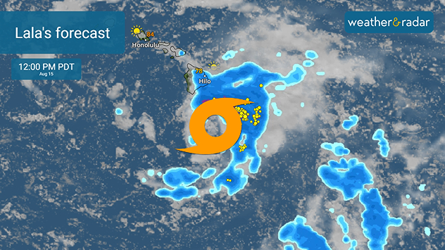
Lala's forecast for Saturday, August 15, 2026, near Hawaii.

Tropical Storm Lala could swipe the shores of the Big Island of Hawaii, possibly near hurricane strength this weekend. The island chain only has two hurricane landfalls on record since 1950, with a close drive-by in 2024 by Hurricane Hone.

The WeatherRadar shows Tropical Storm Lala churning southeast of the Hawaiian Islands on Thursday, and the futurecast takes Lala's tropical impacts right into the island chain this weekend. Already, our Weather & Radar app forecast shows a gusty and rainy Saturday on the Big Island.

Statistically, because the island chain is so small and systems usually stay to the south due to typical high-pressure setups and colder waters, Hawaii doesn't get direct hits often. El Niño can impact things, however.

Warm waters pushing further northward due to this El Niño season have provided a potent environment for eastern Pacific tropical activity, which usually peaks in August. Tropical Storm Lala is taking advantage of the warmer surface temperatures as well as weaker trade winds, allowing the tropical system to drift further north compared to La Niña or neutral seasons.

Becca Parker
More on the topic
Super Typhoon Near the Philippines. Gusts up to 155. . . Tuesday, June 23, 2026
Tuesday, June 23, 2026

Gusts up to 155

Super Typhoon Near the Philippines
Record-breaking heatwave in Europe. Hotter than most of U.S.. . . Thursday, June 25, 2026
Thursday, June 25, 2026

Hotter than most of U.S.

Record-breaking heatwave in Europe
Super Typhoon Bavi threatens Taiwan. 155 mph winds. . Weather Videos. Wednesday, July 8, 2026
The image shows an intense tropical cyclone over the western Pacific, east of Taiwan and the Philippines. The centre of the system is depicted as a light purple and white vortex with a clearly visible eye, surrounded by a ring of red and orange areas indicating the strongest wind speeds. A white arrow marks the typhoon’s predicted track towards the north-west, in the direction of Taiwan. To the west of the storm lie the Philippines, with the cities of Manila and Cebu; to the north of these lies Taiwan, with Taipei. Further west, the Chinese coast, including Hong Kong, and parts of Vietnam can be seen. The coloured wind map shows predominantly green areas outside the storm’s core, indicating significantly weaker winds. White streamlines illustrate the typhoon’s anti-clockwise circulation in the Northern Hemisphere. The highest wind speeds are concentrated around the eye of the cyclone.
Weather VideosWednesday, July 8, 2026

155 mph winds

Super Typhoon Bavi threatens Taiwan
All weather news
This might also interest you
When severe storms strike.... You can be ready. . . Monday, August 10, 2026
Monday, August 10, 2026

You can be ready

When severe storms strike...
Tropical Storm Cristobal and more. Pacific more active. . . Wednesday, August 12, 2026
Wednesday, August 12, 2026

Pacific more active

Tropical Storm Cristobal and more
The meeting of the wet masses. A Florida story. . . Wednesday, August 5, 2026
Two air masses conerge to produce storms & heavy downpours across the Florida Peninsula today.
Wednesday, August 5, 2026

A Florida story

The meeting of the wet masses
All articles
Weather & Radar

Weather & Radar is also available on

Google Play StoreApp Store

Company

Contact us Privacy policy Legal info Accessibility statement

Services

Uploader

Socials

instagramfacebookthreadslinkList