Home
Weather New York
WeatherRadar
RainRadar
TemperatureRadar
WindRadar
LightningRadar
Weather News
Editor's Pick
Discover the app
Weather widget
Contact us
Apps
Career
    Home / Weather News /

    Tropical Storm Cristobal and more

05:23 PM
August 12, 2026

Pacific more active
Tropical Storm Cristobal and more

El Niño highlights the contrast: while the Pacific keeps churning out cyclones, the Atlantic remains eerily calm. Cristobal broke the silence, but without threatening land; however, a system could reach Hawaii directly, which is rare.

Tropical Storm Cristobal formed Wednesday morning. Fortunately, Cristobal is moving across the central Atlantic and will be passing over cooler waters, which will make it very short-lived.

But looking a little farther south, over the tropical Atlantic, we see two tropical waves that have moved off the coast of Africa. We’re at that point in the season when we start seeing more activity moving from the African continent toward the Americas. Fortunately, these two tropical waves are still far away, and we have plenty of time to monitor them.

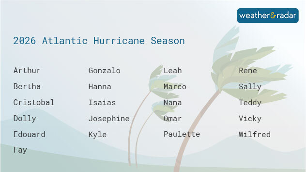
Names for the 2026 Atlantic hurricane season.

The first tropical wave, labeled as Invest 92L if it remains weak, will bring much-needed showers to the Caribbean, a region currently experiencing extreme drought. In fact, many islands, such as Puerto Rico, are under water rationing. If the system were to strengthen a little more as it moves westward, it would remain north of the Caribbean.

Behind this tropical wave is another wave located south of the Cabo Verde Islands. For now, we have plenty of time to monitor it. It currently has a low chance of development over the next seven days. This tropical system would follow a similar path to the first tropical wave mentioned.

The Pacific Stays Active

The Pacific remains highly active. We are currently monitoring a potential tropical cyclone that could affect the Hawaiian Islands this weekend. The WeatherRadar indicates that the system will become better defined as it approaches Hawaii. The next name on the Pacific list is Hernan. If this system makes a direct hit on Hawaii, it would be the first since Hone in 2024.

Learn about our Hurricane alertsread more

Irene Sans
More on the topic
How does fog form?. Multiple ways. . . Saturday, July 11, 2026
Saturday, July 11, 2026

Multiple ways

How does fog form?
Europe: Warmest June on record. Warm waters too. . . Friday, July 10, 2026
The record-breaking heatwave in June has made climate history in Western Europe.
Friday, July 10, 2026

Warm waters too

Europe: Warmest June on record
Waterspouts possible, what are they?. They can be dangerous. . . Sunday, August 9, 2026
Waterspouts weatherradar.
Sunday, August 9, 2026

They can be dangerous

Waterspouts possible, what are they?
All weather news
This might also interest you
The meeting of the wet masses. A Florida story. . . Wednesday, August 5, 2026
Two air masses conerge to produce storms & heavy downpours across the Florida Peninsula today.
Wednesday, August 5, 2026

A Florida story

The meeting of the wet masses
Moisture surge fuels strong storms. Northeast deluge. . . Friday, August 7, 2026
Friday, August 7, 2026

Northeast deluge

Moisture surge fuels strong storms
Wildfire smoke on the WeatherRadar. Air quality concerns. . . Tuesday, August 4, 2026
Tuesday, August 4, 2026

Air quality concerns

Wildfire smoke on the WeatherRadar
All articles
Weather & Radar

Weather & Radar is also available on

Google Play StoreApp Store

Company

Contact us Privacy policy Legal info Accessibility statement

Services

Uploader

Socials

instagramfacebookthreadslinkList