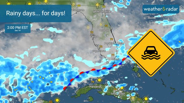
Home / Editor's Pick /

Big rain maker: Florida's flood risk soars, again

01:20 AM
December 13, 2023

Big rain maker
Florida's flood risk soars, again

Recommended external content from YouTube

We need your consent to show content from YouTube. You can withdraw your consent at any time.

I agree that content from YouTube will be displayed to me.

Settings for external content

Privacy policy

It's been a cloudy and soggy day across South Florida. We forecast heavy rains over highly populated areas of southeastern Florida over the next 5 days.

CHECK OUT THE WEATHERRADAR

South Florida residents (and visitors) should pay close attention to the WeatherRadar and forecast. If you have outdoor plans, make sure to have a plan B, the weather will not only continue to deteriorate but the flood risk increases along with the wind for the rest of the week and throughout the weekend.

STRONG GUSTS POSSIBLE: 50 MPH

Stationary front increases the risk of showers for South Florida starting Wednesday.A stationary front increases the risk of showers for South Florida starting Wednesday.

What is happening?

A stationary front near the Florida Straits will increase the risk of rain starting Wednesday for South Florida. This front will stay close enough to increase the flooding risk during the remainder of this work week.

As if that weren't enough and to add to the risk of flooding, a low-pressure system is approaching South Florida over the weekend. This storm will bring a lot of tropical moisture which will contribute to more rain activity from the Keys to the southeastern part of South Florida.

South Florida will get the most extensive period of showers, from Wednesday through Sunday, but the entire peninsula will be mostly affected on Saturday as the low-pressure inches closer, this is the reason why an excessive rain risk has been issued.

Notice how the risk for excessive rain expands all the way north of Central Florida on Saturday. Roads could be flooded, and gusty winds could also make conditions dangerous on the roads for high-profile vehicles. Make sure to secure loose objects in the patio, gardens, and balconies.

How much rain?

In total, between 4 to 8 inches of rain could fall, with some isolated areas with more than 10 inches. For now, the metropolitan areas of Miami-Dade and Broward Counties will be most affected, with the highest rainfall. Cities from Miami, Aventura, Hollywood and Fort Lauderdale could accumulate 8 inches and some isolated spots with higher amounts. Inland regions such as Doral, Miramar, Pembroke Pines, Weston, and Sunrise may see closer to 4 inches.

SOUTH FLORIDA SOAKERS

This could become the 3rd high flood event of the year for South Florida. The first one happened in May when Fort Lauderdale Airport was greatly impacted. The second happened mid-November, when schools closed in Broward County.

That's not all, as the rains move northward, the rainfall will increase over Central and North Florida, too! Orlando and Tampa could receive around 4 inches of rainfall through Monday. Remember there could be some isolated areas, where showers train or become more persistent, getting higher amounts. Turn around, don't drown.

Stay alert to changes to this forecast. We will be tracking the showers and will continue to bring you updates during the week and weekend. Check out our WeatherRadar! You can see the approximate time when showers could arrive in your city.

Strong wind

The wind will be strong at times during the next 5 days. There will be a high risk of rip currents and the sea will be quite rough. Please avoid marine activities, especially if you have small boats.

**This same information can be seen in Spanish, written by our bilingual meteorologists using our app. Tell your family and friends who only speak Spanish so that they can also be informed and stay safe, please.**

Irene Sans
More on the topic
Sleeping cat
Sunday, April 20, 2025

Seasonal tiredness

What causes spring fatigue?
Summer brings the heat and the water activities with it!
Monday, June 2, 2025

Bye, spring!

Meteorological summer is here!
Saturday, April 19, 2025

Your weather - Your shots

Sunrise views and misty mornings
All weather news
This might also interest you
Monday, June 16, 2025

Trout Fire in N.M.

Smoke caught on our WeatherRadar
Severe storms target the high and northern Plains over the weekend.
Saturday, June 14, 2025

You can be ready

When severe storms strike...
Tuesday, June 17, 2025

Daily briefing

Big Plains storms
All articles
Weather & Radar

www.weatherandradar.com

instagramfacebookthreadsContact uslinkList
Privacy policy | Legal info