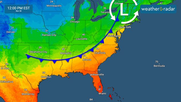
Home
Weather New York
WeatherRadar
RainRadar
TemperatureRadar
WindRadar
LightningRadar
Weather News
Editor's Pick
Discover the app
Weather widget
Contact us
Apps
Career
Home / Weather News /

Big travel day: how's weather affecting it?

10:00 AM
November 27, 2024

Breakfast Brief
Big travel day: how's weather affecting it?

Wednesday is one of the biggest travel days of the year, as many take to the roads and airways to visit loved ones for the Thanksgiving holiday. With winter weather, the Rockies will be the most active. The Breakfast Brief is published every Monday through Friday at 5 a.m. ET.

Heavy rain and snow move into the Intermountain West and Colorado Rockies, where 1-2 feet of snow is possible. Some peaks may even see up to 3 feet. The WeatherRadar shows this storm bringing rain and a wintry mix across the Plains. Impacts will be felt across the East Thursday and Friday. Keep an eye on the WeatherRadar as we continue to track this system.

The same system that will bring rounds of snow to the mountains early Wednesday moves east by the afternoon.
Lake-effect snow explainedread more

The low-pressure system will move south of the Great Lakes and push a cold front, increasing clouds and rain coverage from the southern half of Illinois to the Deep South. The heaviest rains will affect Tennessee, Illinois, Indiana, and Ohio. Snow will be confined to the upper Great Lakes, with mixed precipitation from Chicago through Detroit in the afternoon and evening on Wednesday.

Warming temperatures will be the norm across the Southeast before the incoming cold front arrives on Friday. Keep in mind that this cold front will lose its punch as it moves eastward. Rain is still forecast for northern Georgia and South Carolina, which will arrive by Wednesday night. Check out the TemperatureRadar.

1/2
Winds will increase as the system moves on Wednesday across the Central Plains.

Tropical update:

WOOHOO! There are 3 days left before the official end of the 2024 hurricane season. Tropics continue quiet! There is no chance for tropical storm formation within the next 2 to 7 days.

News we are covering today:

  • Early snow in the mountains
  • Heavy rains for the Great Lakes through the Tennessee Valley

Did you miss these?

Worried about turbulent travel?read more

App news & updates:

Thanksgiving is around the corner! Tune in to the daily travel forecasts!

Irene Sans
More on the topic
rip current
Sunday, March 22, 2026

As more head to the coast

Rip currents & safety tips
Saturday, March 14, 2026

Risks & preparedness

All about nocturnal severe weather
Foggy conditions in the roads. Drive safely, use low beams, high beams reflect more light, obstructing visibility more.
Friday, March 6, 2026

Safety tips: Fog

Driving during foggy conditions
All weather news
This might also interest you
Monday, April 6, 2026

Frost/freeze possible

Spring chill from Midwest to Northeast
Wednesday, April 8, 2026

Dry and windy

Fire threat for the Southeast
Saturday, April 4, 2026

Severe impacts

The dryline and thunderstorms
All articles
Weather & Radar

Weather & Radar is also available on

Google Play StoreApp Store

Company

Contact us Privacy policy Legal info Accessibility statement

Services

Uploader

Socials

instagramfacebookthreadslinkList