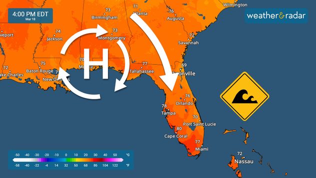
Home
Weather New York
WeatherRadar
RainRadar
TemperatureRadar
WindRadar
LightningRadar
Weather News
Editor's Pick
Discover the app
Weather widget
Contact us
Apps
Career
    Home / Weather News /

    Big winds bring critical fire weather

09:00 AM
March 18, 2025

Breakfast brief
Big winds bring critical fire weather

Another storm system is moving through the Rockies on Tuesday, and very strong winds will increase the fire threat for areas east of the Rockies and through the Central Plains. The Breakfast Brief is published daily, Monday through Friday, at 5:00 a.m. Eastern time.

Two areas will experience strong winds on Tuesday. Florida will continue with a strong northerly flow that will make seas dangerous along both coasts, with winds that could reach 20 mph with stronger gusts. These north winds are also dry, which could propagate any fires that get started. Please avoid fires or anything that could ignite them.

Temperatures will remain around average for this time of year across the Southeast, but srtogn winds will make seas and beaches dangerous.

The other area with stronger winds will extend from Las Vegas and northern Arizona through the Four Corners and West Texas. By the afternoon, extremely strong winds will be across New Mexico and Colorado, mainly from the west-southwest. Gusts could reach 75 mph at times. Across Texas, winds will come from the south, increasing humidity across the Central Plains.

Remember that from central Texas to the west, the winds will be dry and hot as they come from the northern Mexican desert. This dry wind could make fires spread quickly and erratically. Strong winds can also limit visibility as dust is picked up from the ground. Last week, hurricane-force winds killed over 8 people in a 71-vehicle pile-up in Kansas over I-70. There were also several people killed in West Texas due to obstructed visibility on the roads.

These windy conditions are ahead of a low-pressure system that will bring a nice coat of snow to the Rockies. Heavy snow will impact the morning commute from Elko to Salt Lake City and Idaho Falls. By the afternoon, the heavy snow will move over much of Colorado, where it will continue to fall through the evening. Denver will see little snow accumulations, while higher peaks could get up to a foot of snow, which could impact mountain travelers.

The big news on Wednesday will be the temperature drop as this low-pressure system moves eastward. It will take the active weather toward the Great Lakes, but strong winds behind it, mainly from the north, will bring much cooler temperatures, up to 20 degrees below average for many parts of the western half of the U.S.

The news we are covering

  • Critical fire weather
  • Snow over the Rockies
  • Big warm-up for the Northeast
  • Big temperature drop for the west

Things you may have missed

How does weather increase fire risk?read more

App News

It's (almost) spring season. Big weather events break out with low-pressure systems coming from the north or west and battling opposite conditions. There are often tight pressure gradients, which make the winds strong. You can track the change in winds and speed using our WindRadar.

Irene Sans
More on the topic
Heat is affecting agriculture globally. WMO report. . . Sunday, April 26, 2026
A young woman is kneeling in a cornfield, tending to her plants
Sunday, April 26, 2026

WMO report

Heat is affecting agriculture globally
A cloud of Saharan dust over the Mediterranean. On the WeatherRadar. . . Monday, April 13, 2026
Monday, April 13, 2026

On the WeatherRadar

A cloud of Saharan dust over the Mediterranean
All about nocturnal severe weather. Risks & preparedness. . . Saturday, April 18, 2026
Saturday, April 18, 2026

Risks & preparedness

All about nocturnal severe weather
All weather news
This might also interest you
Heat records on both coasts. Summer heat is here. . . Friday, June 12, 2026
Friday records
Friday, June 12, 2026

Summer heat is here

Heat records on both coasts
Multi-day severe threat unleashed. Midwest to Northeast. . . Wednesday, June 10, 2026
A multi-day severe threat targets the Midwest today, with storms impacting the Northeast on Thursday.
Wednesday, June 10, 2026

Midwest to Northeast

Multi-day severe threat unleashed
Tropical downpours soak the Gulf Coast. Widespread flood risk. . . Monday, June 15, 2026
Tropical moisture interacting with a front will bring a multi-day flood threat to the Gulf Coast this week.
Monday, June 15, 2026

Widespread flood risk

Tropical downpours soak the Gulf Coast
All articles
Weather & Radar

Weather & Radar is also available on

Google Play StoreApp Store

Company

Contact us Privacy policy Legal info Accessibility statement

Services

Uploader

Socials

instagramfacebookthreadslinkList