Home
Weather New York
WeatherRadar
RainRadar
TemperatureRadar
WindRadar
LightningRadar
Weather News
Editor's Pick
Discover the app
Weather widget
Contact us
Apps
Career
    Home / Editor's Pick /

    Both coasts dealing with snow, rain, wnid

10:00 AM
November 22, 2024

Breakfast Brief
Both coasts dealing with snow, rain, wind

Rain and snow will affect the West and East Coasts most on Friday, although the system in the West is still causing major problems. The Breakfast Brief is published every Monday through Friday at 5 a.m. ET.

Across the East, a low-pressure system is still exiting the Great Lakes and moving across the Northeast. Snow will still fall across the northern Appalachian Mountains and parts of the interior Northeast and New England. The coastal area will stay with all liquid precipitation. Inland New York could get up to a foot of snow, with some spots up to 16 inches. The coastal TriState area could receive up to 3 inches in some spots.

Out West, the serious threat of floods continues for Friday across northern California. The Cascade Range and upper Sierra Nevada Mountains have a moderate risk, with at least 40 percent of the area at risk of rainfall exceeding flash flood guidance within 25 miles of a point. It might not seem high, but it is a considerable and dangerous risk to residents in this area face that can quickly turn life-threatening.

The almost stationary atmospheric river could bring an additional 6 to 12 inches of rainfall through Saturday. This river of deep moisture will start to wind down on Saturday, but this just means that the deeper moisture will move away. Rounds of showers will still be present through the weekend; this includes mountain snow.

1/2

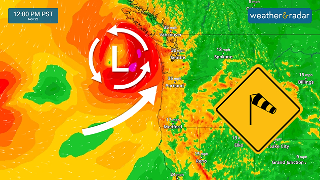
Our WindRadar clearly shows how a persistent low will be parked over the weekend near the Northwest. As a low-pressure system slowly moves near the coast throughout the weekend, strong gusts will affect the Pacific Northwest, including the Oregon coast. Strong gusts could exceed 50 mph, and seas will be rough and dangerous.

November 22, 1992

45 tornadoes touched down in the Tennessee and Ohio Valleys. Georgia was hard hit with two F4, one F3 and three F2 tornadoes that killed six people and injured 144. Indiana had a total of 15 tornadoes on this day to set a record for an outbreak in November and for the month of November. One, an F4 multiple-vortex type, cut a 22-mile path through extreme southeastern Indiana and northern Kentucky. This tornado debunked the myth that twisters don't cross rivers, as this devastating tornado crossed the Ohio River twice. 

Tropical update:

Tropics continue quiet! There is no chance for tropical storm formation within the next 2 to 7 days.

News we are covering today:

  • Cold blast for the East
  • Prolific atmospheric river continues to bring heavy rains for the West

Did you miss these?

Multiple wildfire breakouts across NEread more
Pacifc bomb cyclone closes inread more

App news & updates:

Thanksgiving is around the corner! Tune in to our YouTube page on November 25, 26 and 27, 2024 for live travel forecasts.

Irene Sans
More on the topic
Super Typhoon Bavi threatens Taiwan. 155 mph winds. . Weather Videos. Wednesday, July 8, 2026
The image shows an intense tropical cyclone over the western Pacific, east of Taiwan and the Philippines. The centre of the system is depicted as a light purple and white vortex with a clearly visible eye, surrounded by a ring of red and orange areas indicating the strongest wind speeds. A white arrow marks the typhoon’s predicted track towards the north-west, in the direction of Taiwan. To the west of the storm lie the Philippines, with the cities of Manila and Cebu; to the north of these lies Taiwan, with Taipei. Further west, the Chinese coast, including Hong Kong, and parts of Vietnam can be seen. The coloured wind map shows predominantly green areas outside the storm’s core, indicating significantly weaker winds. White streamlines illustrate the typhoon’s anti-clockwise circulation in the Northern Hemisphere. The highest wind speeds are concentrated around the eye of the cyclone.
Weather VideosWednesday, July 8, 2026

155 mph winds

Super Typhoon Bavi threatens Taiwan
Meteorological summer is here!. Bye, spring!. . . Monday, June 1, 2026
Monday, June 1, 2026

Bye, spring!

Meteorological summer is here!
Europe: Warmest June on record. Warm waters too. . . Friday, July 10, 2026
The record-breaking heatwave in June has made climate history in Western Europe.
Friday, July 10, 2026

Warm waters too

Europe: Warmest June on record
All weather news
This might also interest you
How does a hurricane form?. Hurricane preparedness. . . Sunday, July 19, 2026
hurricane maria
Sunday, July 19, 2026

Hurricane preparedness

How does a hurricane form?
Lopsided Bertha moves west. Who sees the impacts. . . Thursday, July 23, 2026
Thursday, July 23, 2026

Who sees the impacts

Lopsided Bertha moves west
When severe storms strike.... You can be ready. . . Sunday, July 26, 2026
Sunday, July 26, 2026

You can be ready

When severe storms strike...
All articles
Weather & Radar

Weather & Radar is also available on

Google Play StoreApp Store

Company

Contact us Privacy policy Legal info Accessibility statement

Services

Uploader

Socials

instagramfacebookthreadslinkList