Home
Weather New York
WeatherRadar
RainRadar
TemperatureRadar
WindRadar
LightningRadar
Weather News
Editor's Pick
Discover the app
Weather widget
Contact us
Apps
Career
    Home / Editor's Pick /

    Breakfast Brief: Fla. preps for Milton

09:00 AM
October 8, 2024

Breakfast Brief
Fla. preps for Milton, quiet U.S.

Conditions are deteriorating across Florida's Gulf Coast today as Major Hurricane Milton churns across the Gulf of Mexico. A few showers will slide into the Northwest and depart the Northeast. Quiet everywhere else.

The WeatherRadar shows heavy rain moving across Florida well ahead of Milton's arrival on Wednesday. This will slow preparation efforts even as the clock winds down to be at a safe place.

Milton's historical facts

Milton's max wind of 180 mph on Monday night was the highest for a hurricane in the Gulf of Mexico this late in the year. Only two other Gulf hurricanes, Rita in 2005 and Allen in 1980, have had winds that strong.   

An incoming autumn storm will move into the Pacific Northwest later Tuesday. This will bring rain to the coastal range and some late showers to Seattle and Portland. On the opposite corner of the U.S., rain will be departing New England.

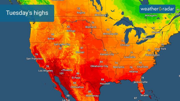
The TemperatureRadar shows the warm October continuing across the U.S. Highs will be in the 70s and 80s across much of the U.S., with the Southwest and interior California remaining the hot spots as highs climb into the triple digits again. The New England rain and clouds will suppress temperatures with highs in the 60s.

Tuesday's highs.

Tropical update:

The tropical focus remains in the Gulf of Mexico. Major Hurricane Milton is moving towards Florida and will make landfall on Wednesday, likely as a Category 3 or 4 hurricane. It will slam the Sunshine State with destructive storm surge, damaging winds and inland flooding. Check back for the latest information.

Kirk is now a powerful north Atlantic storm after losing its tropical characteristics Monday. Leslie will continue to weaken as it moves over central Atlantic. A small disturbance over eastern Florida could move into the Atlantic and could develop into a weak tropical system over the next several days as it moves over the Gulf Stream.

News we are covering today:

  • Milton forecast
  • Preparing for Milton

Did you miss these?

Florida prepares for Miltonread more
Milton rapidly intensifiesread more

App news & updates:

Hurricane season in the Atlantic doesn't end until Nov. 30. Are your hurricane alerts on? Check here.

James West
More on the topic
Hawaii's second 2026 hurricane impact. Hurricane Lowell. . . Tuesday, September 8, 2026
Tuesday, September 8, 2026

Hurricane Lowell

Hawaii's second 2026 hurricane impact
10 facts about fog. Low clouds. . . Sunday, September 27, 2026
Fog impacting the Appalachian Mountains.
Sunday, September 27, 2026

Low clouds

10 facts about fog
All about nocturnal severe weather. Risks & preparedness. . . Saturday, September 5, 2026
Saturday, September 5, 2026

Risks & preparedness

All about nocturnal severe weather
All weather news
This might also interest you
1,800 miles of rain. From Texas to Michigan. . . Thursday, October 1, 2026
Thursday, October 1, 2026

From Texas to Michigan

1,800 miles of rain
Hurricane drought in the Atlantic. 352 days and counting. . . Wednesday, September 30, 2026
The last hurricane to form in the Atlantic was Hurricane Melissa on October 13, 2025, 352 days ago. So what's responsible for this hurricane drought?
Wednesday, September 30, 2026

352 days and counting

Hurricane drought in the Atlantic
Autumn foliage: weather's impact. Leaf-peeping season!. . . Sunday, October 4, 2026
Cool nights can help intensify autumn foliage color!
Sunday, October 4, 2026

Leaf-peeping season!

Autumn foliage: weather's impact
All articles
Weather & Radar

Weather & Radar is also available on

Google Play StoreApp Store

Company

Contact us Privacy policy Legal info Accessibility statement

Services

Uploader

Socials

instagramfacebookthreadslinkList