Home
Weather New York
WeatherRadar
RainRadar
TemperatureRadar
WindRadar
LightningRadar
Weather News
Editor's Pick
Discover the app
Weather widget
Contact us
Apps
Career
    Home / Weather News /

    Breakfast Brief: Flood threat for the Central Gulf Coast

09:00 AM
May 29, 2025

Breakfast Brief
Flood threat for the central Gulf Coast
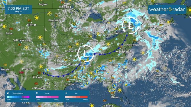
Heavy rain will bring a flood threat to the central Gulf Coast today. Heat builds in the Northwest, with cooler-than-average temperatures lingering from the central Plains to the Northeast. The Breakfast Brief is published Monday through Friday at 5:00 a.m. Eastern Time.

The WeatherRadar shows scattered showers and storms across much of the eastern two-thirds of the country. Gulf moisture will bring 1-3 inches of rain to the central Gulf Coast, increasing the risk of flash flooding. Cities like New Orleans, Jackson, Miss., Mobile, Ala., and Tallahassee, Fla., should be alert to possible flooding in downpours.

Isolated strong storms are also possible from New Mexico to Georgia this afternoon and evening. Damaging winds and hail are possible. Make sure your Weather & Radar app alerts are on.

The TemperatureRadar shows cooler-than-average temperatures across the southern and central Plains into the Northeast and Mid-South. Warmer-than-average temperatures are forecast for much of the western half of the country.

Conditions will be comfortable along I-95, with highs in New York, Washington, D.C., and Philadelphia reaching the 70s. Cooler-than-average highs are expected in Oklahoma City and Kansas City, Mo., where highs will make it to the upper 60s.

While the coast remains cool, the interior West will continue to heat up. Phoenix will once again reach the triple-digits, while Salt Lake City nears a high of 90, and Boise, Idaho, reaches the mid-90s.

News we're covering today

  • Flood threat across the central Gulf Coast
  • Heat building across the Western half
Rip currents & saftey tipsread more

App news

When severe weather is in your forecast, you can be prepared. Follow along with these tools to stay weather-aware.

Mary Mays
More on the topic
The average first frosts in the U.S.. Meteorological autumn. . . Sunday, October 4, 2026
First frosts can begin in September as autumn temps move in.
Sunday, October 4, 2026

Meteorological autumn

The average first frosts in the U.S.
Hawaii's second 2026 hurricane impact. Hurricane Lowell. . . Tuesday, September 8, 2026
Tuesday, September 8, 2026

Hurricane Lowell

Hawaii's second 2026 hurricane impact
Hurricane Polo remains dangerous. Active Pacific. . . Thursday, September 24, 2026
Thursday, September 24, 2026

Active Pacific

Hurricane Polo remains dangerous
All weather news
This might also interest you
October's rain doubled in just days. Flooding possible. . . Tuesday, October 13, 2026
Tuesday, October 13, 2026

Flooding possible

October's rain doubled in just days
Santa Ana winds start up. Southern California. . . Thursday, October 15, 2026
Thursday, October 15, 2026

Southern California

Santa Ana winds start up
First tropical storm since the 90s?. Southern California. . . Friday, October 9, 2026
Friday, October 9, 2026

Southern California

First tropical storm since the 90s?
All articles
Weather & Radar

Weather & Radar is also available on

Google Play StoreApp Store

Company

Contact us Privacy policy Legal info Accessibility statement

Services

Uploader

Socials

instagramfacebookthreadslinkList