Home / Editor's Pick /

Breakfast Brief: Florida floods, stormy Midwest

09:00 AM
June 12, 2024

Breakfast brief
Florida floods, stormy Midwest

Florida continues to face heavy rains and flooding, while the East is in the midst of a warming trend that will bring back summer heat. The West is a tale of two, with the Pacific Northwest staying cool and rainy and the Southwest enduring dangerously hot conditions.

Did you know?

On this day, in 1998, a severe thunderstorm produced baseball-sized hail in Oklahoma City, Oklahoma, causing widespread damage to vehicles, roofs, and windows, and leading to millions of dollars in damages

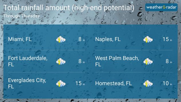
Today's weather outlook

Not much will change across the Florida Peninsula on Wednesday as deep tropical moisture continues to spark showers and isolated thunderstorms. South Florida is expected to bear the brunt of the rain, particularly southwest Florida, where localized amounts over a foot are possible. Cities like Naples, Fort Lauderdale, Venice, and Vero Beach are on track to see their wettest June on record.

The Northeast will experience cooler temperatures with intermittent showers, but a gradual warming trend will bring temperatures back into the 80s and lower 90s in places like Washington D.C. and Philadelphia by the weekend. Across the Midwest, scattered severe thunderstorms capable of large hail, damaging winds, and a few tornadoes will be possible, with Minnesota and northern Iowa being the focus areas for dangerous storms.

rainfall totals through thursday

Across the West, the weather will vary significantly by region. The Pacific Northwest will enjoy mostly clear skies with slightly below-normal temperatures. Meanwhile, the Southwest will continue to experience unseasonably warm weather, with temperatures soaring in desert lowland areas. California will see mostly clear skies with mild coastal temperatures, though inland areas will be much hotter during the day, with temperatures reaching the 100-degree mark.

Tropical update

The downpours affecting Florida this week are associated with deep tropical moisture emanating from the western Caribbean. Over the next day or two, an area of low pressure will move over Florida and migrate over the peninsula, with a low chance of development into a tropical cyclone. There is a 20% chance of development over the next day. The main impacts of this system continue to be heavy, widespread rain, bringing an increased threat of flash flooding. There is another area that has a low chance of developing over the western Gulf of Mexico within the next 7 days.

The news we're covering today:

  • Heavy rainfall leads to flash flooding in Florida: watch what happened overnight!
  • NASA records a year of monthly temperature records
  • Severe weather affects the Upper Midwest

Did you miss these?

Size of hail that damages your carread more
Plane struck by hail mid-flightread more
Preparing for 2024 hurricane seasonread more

App news & updates:

Did you know you can receive notifications for incoming tropical systems? Our storm alert feature keeps you informed about dangerous winds, heavy rain, or storm surge in your area. Simply turn on your alerts to stay updated. Find out how here.

Federico Di Catarina
More on the topic
Waterspouts weatherradar.
Monday, May 26, 2025

They can be dangerous

Waterspouts possible, what are they?
Saturday, April 26, 2025

Off the coast of Sardinia

Waterspout seen from cruise ship
Saturday, May 3, 2025

May astronomy outlook

Meteor shower and the Flower Moon
All weather news
This might also interest you
Happy Father's Day!
Sunday, June 15, 2025

Check the forecast

Happy Father's Day!
Severe storms target the high and northern Plains over the weekend.
Saturday, June 14, 2025

You can be ready

When severe storms strike...
Drink plenty of water
Monday, June 16, 2025

Top & silent killer

9 tips to stay safe from the heat
All articles
Weather & Radar

www.weatherandradar.com

instagramfacebookthreadsContact uslinkList
Privacy policy | Legal info