Home
Weather New York
WeatherRadar
RainRadar
TemperatureRadar
WindRadar
LightningRadar
Weather News
Editor's Pick
Discover the app
Weather widget
Contact us
Apps
Career
    Home / Editor's Pick /

    Breakfast Brief: Florida floods, stormy Midwest

09:00 AM
June 12, 2024

Breakfast brief
Florida floods, stormy Midwest

Florida continues to face heavy rains and flooding, while the East is in the midst of a warming trend that will bring back summer heat. The West is a tale of two, with the Pacific Northwest staying cool and rainy and the Southwest enduring dangerously hot conditions.

Did you know?

On this day, in 1998, a severe thunderstorm produced baseball-sized hail in Oklahoma City, Oklahoma, causing widespread damage to vehicles, roofs, and windows, and leading to millions of dollars in damages

Today's weather outlook

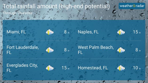
Not much will change across the Florida Peninsula on Wednesday as deep tropical moisture continues to spark showers and isolated thunderstorms. South Florida is expected to bear the brunt of the rain, particularly southwest Florida, where localized amounts over a foot are possible. Cities like Naples, Fort Lauderdale, Venice, and Vero Beach are on track to see their wettest June on record.

The Northeast will experience cooler temperatures with intermittent showers, but a gradual warming trend will bring temperatures back into the 80s and lower 90s in places like Washington D.C. and Philadelphia by the weekend. Across the Midwest, scattered severe thunderstorms capable of large hail, damaging winds, and a few tornadoes will be possible, with Minnesota and northern Iowa being the focus areas for dangerous storms.

rainfall totals through thursday

Across the West, the weather will vary significantly by region. The Pacific Northwest will enjoy mostly clear skies with slightly below-normal temperatures. Meanwhile, the Southwest will continue to experience unseasonably warm weather, with temperatures soaring in desert lowland areas. California will see mostly clear skies with mild coastal temperatures, though inland areas will be much hotter during the day, with temperatures reaching the 100-degree mark.

Tropical update

The downpours affecting Florida this week are associated with deep tropical moisture emanating from the western Caribbean. Over the next day or two, an area of low pressure will move over Florida and migrate over the peninsula, with a low chance of development into a tropical cyclone. There is a 20% chance of development over the next day. The main impacts of this system continue to be heavy, widespread rain, bringing an increased threat of flash flooding. There is another area that has a low chance of developing over the western Gulf of Mexico within the next 7 days.

The news we're covering today:

  • Heavy rainfall leads to flash flooding in Florida: watch what happened overnight!
  • NASA records a year of monthly temperature records
  • Severe weather affects the Upper Midwest

Did you miss these?

Size of hail that damages your carread more
Plane struck by hail mid-flightread more
Preparing for 2024 hurricane seasonread more

App news & updates:

Did you know you can receive notifications for incoming tropical systems? Our storm alert feature keeps you informed about dangerous winds, heavy rain, or storm surge in your area. Simply turn on your alerts to stay updated. Find out how here.

Federico Di Catarina
More on the topic
High pressure & extreme heat. Why & how does it work?. . . Sunday, July 12, 2026
Sunday, July 12, 2026

Why & how does it work?

High pressure & extreme heat
Meteorological summer is here!. Bye, spring!. . . Monday, June 1, 2026
Monday, June 1, 2026

Bye, spring!

Meteorological summer is here!
Super Typhoon Bavi threatens Taiwan. 155 mph winds. . Weather Videos. Wednesday, July 8, 2026
The image shows an intense tropical cyclone over the western Pacific, east of Taiwan and the Philippines. The centre of the system is depicted as a light purple and white vortex with a clearly visible eye, surrounded by a ring of red and orange areas indicating the strongest wind speeds. A white arrow marks the typhoon’s predicted track towards the north-west, in the direction of Taiwan. To the west of the storm lie the Philippines, with the cities of Manila and Cebu; to the north of these lies Taiwan, with Taipei. Further west, the Chinese coast, including Hong Kong, and parts of Vietnam can be seen. The coloured wind map shows predominantly green areas outside the storm’s core, indicating significantly weaker winds. White streamlines illustrate the typhoon’s anti-clockwise circulation in the Northern Hemisphere. The highest wind speeds are concentrated around the eye of the cyclone.
Weather VideosWednesday, July 8, 2026

155 mph winds

Super Typhoon Bavi threatens Taiwan
All weather news
This might also interest you
Lopsided Bertha moves west. Who sees the impacts. . . Thursday, July 23, 2026
Thursday, July 23, 2026

Who sees the impacts

Lopsided Bertha moves west
Multi-Day flood threat for Mid-Atlantic. Stalled front. . . Wednesday, July 22, 2026
Wednesday, July 22, 2026

Stalled front

Multi-Day flood threat for Mid-Atlantic
Up to four feet of storm surge. Gulf Coast soaker. . . Tuesday, July 21, 2026
Tropical storm alerts are active in the app as Bertha continues to churn in the northern Gulf.
Tuesday, July 21, 2026

Gulf Coast soaker

Up to four feet of storm surge
All articles
Weather & Radar

Weather & Radar is also available on

Google Play StoreApp Store

Company

Contact us Privacy policy Legal info Accessibility statement

Services

Uploader

Socials

instagramfacebookthreadslinkList