Home
Weather New York
WeatherRadar
RainRadar
TemperatureRadar
WindRadar
LightningRadar
Weather News
Editor's Pick
Discover the app
Weather widget
Contact us
Apps
Career
    Home / Weather News /

    Breakfast Brief: More storms from Texas to the Southeast
09:00 AM
May 28, 2025

Breakfast Brief
More storms from Texas to the Southeast

Showers and storms will impact areas stretching from Texas to the Southeast today. While the central and eastern parts of the country experience cooler-than-average temperatures, heat will build across much of the western half. The Breakfast Brief is published Monday through Friday at 5:00 a.m. Eastern Time.

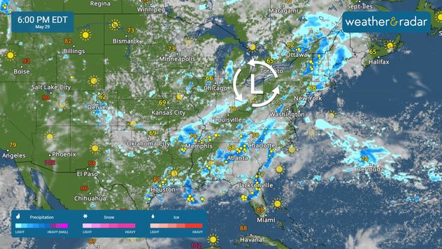
The WeatherRadar shows storms stretching from the southern Plains into the Southeast today. Scattered rain and storms are also forecast for parts of the Mid-South, Great Lakes, Mid-Atlantic and Northeast. The West Coast will stay dry today.

A few strong storms may develop in west Texas and across the Texas and Oklahoma panhandles. Damaging winds and hail will be the main threats, but an isolated tornado cannot be ruled out. Make sure your Weather & Radar app alerts are on.

The TemperatureRadar shows cooler-than-average temperatures across the southern and central Plains into the Northeast and Mid-South. Warmer-than-average temperatures are forecast for much of the western half of the country.

Highs in cities like Minneapolis and Chicago will be in the 60s, while the 70s extend into the Southeast. The heat will build out west with Boise hitting the 90s and Phoenix seeing triple-digits.

The TemperatureRadar is a great tool for observing today's highs and lows in your area and across the U.S.

News we're covering today

  • Strong storms possible in Texas
  • Heat building across the Western half
Rip currents & saftey tipsread more

App news

When severe weather is in your forecast, you can be prepared. Follow along with these tools to stay weather-aware.

Mary Mays
More on the topic
Meteorological summer is here!. Bye, spring!. . . Monday, June 1, 2026
Monday, June 1, 2026

Bye, spring!

Meteorological summer is here!
High pressure & extreme heat. Why & how does it work?. . . Sunday, June 28, 2026
Sunday, June 28, 2026

Why & how does it work?

High pressure & extreme heat
El Niño is gaining momentum. Temperature records?. . . Thursday, May 7, 2026
The image shows the central Pacific in a computer model. A striking feature is the ocean coloured red, which indicates very warm seawater.
Thursday, May 7, 2026

Temperature records?

El Niño is gaining momentum
All weather news
This might also interest you
Fireworks and Air Quality. Smoke and pollution. . . Saturday, July 4, 2026
Saturday, July 4, 2026

Smoke and pollution

Fireworks and Air Quality
Saharan dust to reach Florida. Dry period expected. . . Tuesday, July 7, 2026
Saharan dust seen on the satllite image (right) moving westward toward Florida. Air quality impacts are expected.
Tuesday, July 7, 2026

Dry period expected

Saharan dust to reach Florida
Hotter in Detroit than Miami. Heatwave begins. . . Tuesday, June 30, 2026
Tuesday, June 30, 2026

Heatwave begins

Hotter in Detroit than Miami
All articles
Weather & Radar

Weather & Radar is also available on

Google Play StoreApp Store

Company

Contact us Privacy policy Legal info Accessibility statement

Services

Uploader

Socials

instagramfacebookthreadslinkList