Home
Weather New York
WeatherRadar
RainRadar
TemperatureRadar
WindRadar
LightningRadar
Weather News
Editor's Pick
Discover the app
Weather widget
Contact us
Apps
Career
    Home / Weather News /

    Breakfast brief: Multi-day severe threat

09:00 AM
April 25, 2024

Breakfast brief
Multi-day severe threat

A multi-day severe weather threat begins in earnest for the Plains today and continues through the weekend. Cooler air and moisture returns to the Northwest.

Coldest April temperature on record

The temperature at Eagles Nest, NM, plunged to 45 degrees below zero to establish an April record for the United States.

Today's weather outlook

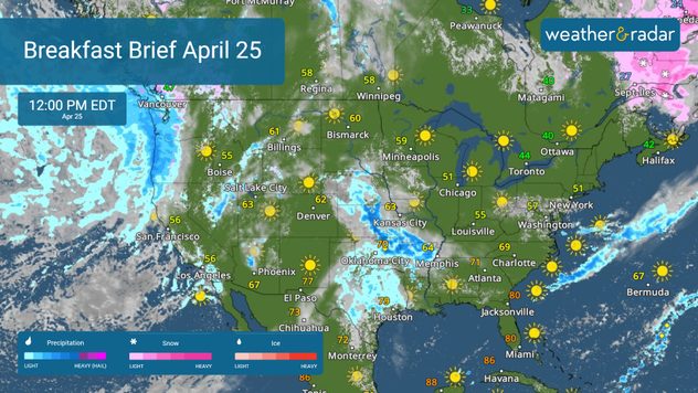
Residents of the Plains should monitor the WeatherRadar as the threat of severe weather grows later today and through the end of the week. While showers will be present during the day today across the central and southern Plains, the severe threat ramps up this evening and overnight. All kinds of severe weather, including hail, winds, tornadoes, and flooding, are possible with these storms. The greatest risk extends from central Texas northward through western Kansas.

WeatherRadar April 25

Rain and mountain snow will continue to impact the Pacific Northwest today. With highs only in the 50s in spots like Seattle, this region will experience a dreary second half of the week.

News we're covering today:

  • Multi-day severe threat underway.
  • Cooler and wetter in the Northwest.

Did you miss these?

Desert dust turns sky red in Athensread more
Quadruple solar flares observedread more
Voyager 1 updateread more

App news & updates:

With a multi-day severe weather threat underway, now is the time to make sure your Weather & Radar alerts are turned on. Click the link below to learn more about how to make sure you are getting the most up-to-date alerts for your area.

How to turn on weather alertsread more

More on the topic

Record ocean heat halting hurricanes. Strong El Niño influence. . . Sunday, September 13, 2026
A weather map shows a calm Atlantic Ocean with no hurricanes, alongside a picture of the sea.
Sunday, September 13, 2026

Strong El Niño influence

Record ocean heat halting hurricanes
What are weather fronts?. Weather explained. . . Saturday, October 24, 2026
Image of a temperature radar showing a clear distinction between a warm and cold air mass separated by a cold front.
Saturday, October 24, 2026

Weather explained

What are weather fronts?
The average first frosts in the U.S.. Meteorological autumn. . . Sunday, October 18, 2026
First frosts can begin in September as autumn temps move in.
Sunday, October 18, 2026

Meteorological autumn

The average first frosts in the U.S.
All weather news

This might also interest you

Orionid Meteor Shower Peaks. Seeing stars. . . Tuesday, October 20, 2026
Tuesday, October 20, 2026

Seeing stars

Orionid Meteor Shower Peaks
Gravity wave clouds explained. The ideal conditions. . . Saturday, October 17, 2026
Saturday, October 17, 2026

The ideal conditions

Gravity wave clouds explained
Rare tornado risk accompanies flood risk. Autumn tropical influx. . . Wednesday, October 21, 2026
Southwest rainfall
Wednesday, October 21, 2026

Autumn tropical influx

Rare tornado risk accompanies flood risk
All articles
Weather & Radar

Weather & Radar is also available on

Google Play StoreApp Store

Company

Contact us Privacy policy Legal info Accessibility statement

Services

Uploader

Socials

instagramfacebookthreadslinkList