Home
Weather New York
WeatherRadar
RainRadar
TemperatureRadar
WindRadar
LightningRadar
Weather News
Editor's Pick
Discover the app
Weather widget
Contact us
Apps
Career
    Home / Weather News /

    Breakfast brief: Showers stretch from Texas to Midwest

09:00 AM
April 23, 2024

Breakfast brief
Showers stretch from Texas to Midwest

Relatively quiet conditions remain in place across much of the U.S. today. However, a few showers and storms will be possible stretching from the southern Plains to the Midwest and Northeast later today and into tonight.

Coldest April temperature on record

The temperature at Eagles Nest, NM, plunged to 45 degrees below zero to establish an April record for the United States.

Today's weather outlook

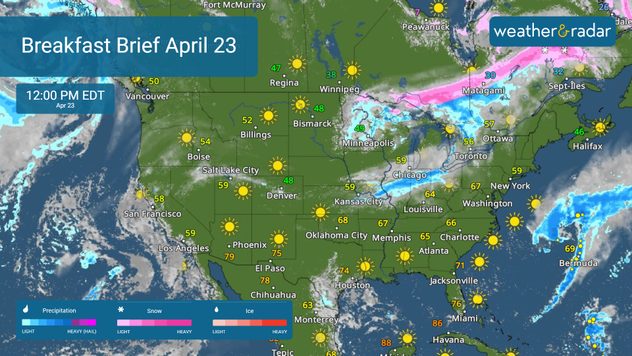
The WeatherRadar shows quiet weather again for much of the U.S. However, a few showers and storms will break out along a front stretching from the southern Plains to the Midwest this afternoon. By tonight, rain showers are expected to move into the Northeast. Severe storms are unlikely; however, a few strong storms may develop in north-central Texas and Michigan.

WeatherRadar April 23

You will also want to keep an eye on our TemperatureRadar this afternoon. Temperatures are warming up quickly across the South, where highs will return to the 70s in cities like Atlanta, Nashville, Tenn., and Houston.

News we're covering today:

  • Rain stretches from the Plains to the Northeast.
  • Warmer weather for the South.

Did you miss these?

Famous Dutch tulips bloom earlyread more
Late-week severe threatread more

App news & updates:

Are you ready for severe weather? With the threat of storms building in by the end of the week, it's important to turn on your Weather & Radar app alerts. Find out how by clicking on the link below.

How to turn on weather alertsread more
More on the topic
Longest day of the year is here. Summer solstice. . . Sunday, June 21, 2026
Sunday, June 21, 2026

Summer solstice

Longest day of the year is here
Super Typhoon Bavi threatens Taiwan. 155 mph winds. . Weather Videos. Wednesday, July 8, 2026
The image shows an intense tropical cyclone over the western Pacific, east of Taiwan and the Philippines. The centre of the system is depicted as a light purple and white vortex with a clearly visible eye, surrounded by a ring of red and orange areas indicating the strongest wind speeds. A white arrow marks the typhoon’s predicted track towards the north-west, in the direction of Taiwan. To the west of the storm lie the Philippines, with the cities of Manila and Cebu; to the north of these lies Taiwan, with Taipei. Further west, the Chinese coast, including Hong Kong, and parts of Vietnam can be seen. The coloured wind map shows predominantly green areas outside the storm’s core, indicating significantly weaker winds. White streamlines illustrate the typhoon’s anti-clockwise circulation in the Northern Hemisphere. The highest wind speeds are concentrated around the eye of the cyclone.
Weather VideosWednesday, July 8, 2026

155 mph winds

Super Typhoon Bavi threatens Taiwan
Europe: Warmest June on record. Warm waters too. . . Friday, July 10, 2026
The record-breaking heatwave in June has made climate history in Western Europe.
Friday, July 10, 2026

Warm waters too

Europe: Warmest June on record
All weather news
This might also interest you
Multi-Day flood threat for Mid-Atlantic. Stalled front. . . Wednesday, July 22, 2026
Wednesday, July 22, 2026

Stalled front

Multi-Day flood threat for Mid-Atlantic
Temps 15-degrees below average. Big cold front. . . Wednesday, July 22, 2026
Wednesday, July 22, 2026

Big cold front

Temps 15-degrees below average
Southwest heat disrupts daily flow. Closures & delays. . . Monday, July 27, 2026
Monday, July 27, 2026

Closures & delays

Southwest heat disrupts daily flow
All articles
Weather & Radar

Weather & Radar is also available on

Google Play StoreApp Store

Company

Contact us Privacy policy Legal info Accessibility statement

Services

Uploader

Socials

instagramfacebookthreadslinkList