Home
Weather New York
WeatherRadar
RainRadar
TemperatureRadar
WindRadar
LightningRadar
Weather News
Editor's Pick
Discover the app
Weather widget
Contact us
Apps
Career
    Home / Weather News /

    Check the WindRadar - Spring's big winds

09:00 AM
March 28, 2026

Check the WindRadar
Spring's big winds

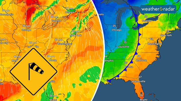
A strong cold front triggers gusty winds.
A strong cold front triggers gusty winds across the eastern U.S. as a storm system moves through.

As we get deeper into spring and the warm and cold air bring a roller coaster of temperatures, big wind gusts usually accompany the transition.

One day it's in the 70s with plentiful sunshine and evening thunderstorms. The next day, you're back in your winter coat with snow flurries and blustery winds. Many may even experience all four seasons in one day! This is all thanks to the clash of warm and cold air masses - creating big spring winds.

What is transition season?read more

The winds are created by two atmospheric mechanisms over a small distance: a fast change in pressure or a fast change in temperature.

The TemperatureRadar can show you where a tight gradient of temperatures is occurring, thanks to a cold front. When this is happening, check the WindRadar. We bet you'll see gusty wind activity.

Learn more about the WindRadarread more
Becca Parker
More on the topic
Record-breaking heatwave in Europe. Hotter than most of U.S.. . . Thursday, June 25, 2026
Thursday, June 25, 2026

Hotter than most of U.S.

Record-breaking heatwave in Europe
Super Typhoon Bavi threatens Taiwan. 155 mph winds. . Weather Videos. Wednesday, July 8, 2026
The image shows an intense tropical cyclone over the western Pacific, east of Taiwan and the Philippines. The centre of the system is depicted as a light purple and white vortex with a clearly visible eye, surrounded by a ring of red and orange areas indicating the strongest wind speeds. A white arrow marks the typhoon’s predicted track towards the north-west, in the direction of Taiwan. To the west of the storm lie the Philippines, with the cities of Manila and Cebu; to the north of these lies Taiwan, with Taipei. Further west, the Chinese coast, including Hong Kong, and parts of Vietnam can be seen. The coloured wind map shows predominantly green areas outside the storm’s core, indicating significantly weaker winds. White streamlines illustrate the typhoon’s anti-clockwise circulation in the Northern Hemisphere. The highest wind speeds are concentrated around the eye of the cyclone.
Weather VideosWednesday, July 8, 2026

155 mph winds

Super Typhoon Bavi threatens Taiwan
Meteorological summer is here!. Bye, spring!. . . Monday, June 1, 2026
Monday, June 1, 2026

Bye, spring!

Meteorological summer is here!
All weather news
This might also interest you
6 easy steps to take now to be ready. Hurricane preparedness. . . Sunday, August 9, 2026
Are you ready?
Sunday, August 9, 2026

Hurricane preparedness

6 easy steps to take now to be ready
Heat not felt in 80+ years. Pacific Northwest. . . Tuesday, August 4, 2026
Records as old as 81 and even 124 years could fall this first week of August in the Pacific Northwest as temperatures rise to the 90s & triple digits due to a new heatwave.
Tuesday, August 4, 2026

Pacific Northwest

Heat not felt in 80+ years
Moisture surge fuels strong storms. Northeast deluge. . . Friday, August 7, 2026
Friday, August 7, 2026

Northeast deluge

Moisture surge fuels strong storms
All articles
Weather & Radar

Weather & Radar is also available on

Google Play StoreApp Store

Company

Contact us Privacy policy Legal info Accessibility statement

Services

Uploader

Socials

instagramfacebookthreadslinkList