Home
Weather New York
WeatherRadar
RainRadar
TemperatureRadar
WindRadar
LightningRadar
Weather News
Editor's Pick
Discover the app
Weather widget
Contact us
Apps
Career
    Home / Weather News /

    Closures & delays - Southwest heat disrupts daily flow

01:20 PM
July 27, 2026

Closures & delays
Southwest heat disrupts daily flow

Disruptions to the daily flow of life in the Southwest are top of mind recently, as intense heat and humidity have kept visitors off hiking trails and bumped passengers off flights.

Southwest residents are no strangers to triple-digit heat, especially since it's usually a dry heat. But humidity levels have been higher than usual for this time of year, driving up the heat index and making it feel much hotter. Phoenix-area hiking trails are closed during the hottest times of day.

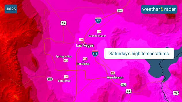
The heat has had the TemperatureRadar turn hues of bright red to hot pink across the Southwest. In Las Vegas, for those flying out of Harry Reid International Airport, safety concerns in the heat forced airlines to activate weight restrictions, bumping passengers off of their scheduled flights over the weekend.

It's hard for a plane to take off in such intense heat. With these triple-digit temperatures, the more weight, the less thrust from the engines, causing safety concerns. Hundreds of flights were delayed.

Saturday's high temperatures in the Las Vegas area.

Temperatures are expected to increase gradually throughout this week, so more disruptions are possible.

Becca Parker
More on the topic
Record-breaking heatwave in Europe. Hotter than most of U.S.. . . Thursday, June 25, 2026
Thursday, June 25, 2026

Hotter than most of U.S.

Record-breaking heatwave in Europe
Super Typhoon Near the Philippines. Gusts up to 155. . . Tuesday, June 23, 2026
Tuesday, June 23, 2026

Gusts up to 155

Super Typhoon Near the Philippines
Super Typhoon Bavi threatens Taiwan. 155 mph winds. . Weather Videos. Wednesday, July 8, 2026
The image shows an intense tropical cyclone over the western Pacific, east of Taiwan and the Philippines. The centre of the system is depicted as a light purple and white vortex with a clearly visible eye, surrounded by a ring of red and orange areas indicating the strongest wind speeds. A white arrow marks the typhoon’s predicted track towards the north-west, in the direction of Taiwan. To the west of the storm lie the Philippines, with the cities of Manila and Cebu; to the north of these lies Taiwan, with Taipei. Further west, the Chinese coast, including Hong Kong, and parts of Vietnam can be seen. The coloured wind map shows predominantly green areas outside the storm’s core, indicating significantly weaker winds. White streamlines illustrate the typhoon’s anti-clockwise circulation in the Northern Hemisphere. The highest wind speeds are concentrated around the eye of the cyclone.
Weather VideosWednesday, July 8, 2026

155 mph winds

Super Typhoon Bavi threatens Taiwan
All weather news
This might also interest you
Multi-day rain event ends soon. Southeast U.S.. . . Friday, July 24, 2026
Friday, July 24, 2026

Southeast U.S.

Multi-day rain event ends soon
Gulf system is becoming better organized. It moves slowly. . . Monday, July 20, 2026
Monday, July 20, 2026

It moves slowly

Gulf system is becoming better organized
How does a hurricane form?. Hurricane preparedness. . . Sunday, July 19, 2026
hurricane maria
Sunday, July 19, 2026

Hurricane preparedness

How does a hurricane form?
All articles
Weather & Radar

Weather & Radar is also available on

Google Play StoreApp Store

Company

Contact us Privacy policy Legal info Accessibility statement

Services

Uploader

Socials

instagramfacebookthreadslinkList