Home
Weather New York
WeatherRadar
RainRadar
TemperatureRadar
WindRadar
LightningRadar
Weather News
Editor's Pick
Discover the app
Weather widget
Contact us
Apps
Career
    Home / Weather News /

    Coastal low to slam New England

03:46 PM
July 28, 2024

Downpours, strong winds
Coastal storm to slam New England

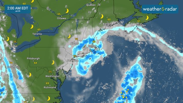
The weather pattern picks up for the northeast, and more directly New England starting tonight with more unsettled weather towards the middle of the week and temperatures that could be scorching.

A coastal low-pressure system will be moving close to the northeast coast late on Sunday. This low-pressure system promises to bring dangerous conditions offshore and high seas near the beach. Our WindRadar shows the storm bringing wind speeds up at least 65 mph near its center. The storm could also enhance the rain chances for eastern New York through New England.

A low-pressure system will bring rounds of downpours to the Northeast and New England area, and minor flooding over flood-prone areas is likely.

The good news is that this system will be short-lived. Expect unsettled weather to start Sunday night and last through the first half of the day on Monday. By the middle of the week, there will be several impulses of unsettled weather that promise to bring a higher chance for thunderstorms. A cold front will try to approach the area by Wednesday. This will increase thunderstorm and rain activity from the tri-state area through New England.

The atmosphere will be prepping the area with plenty of moisture between Monday and Tuesday and this will aid the chance for heavy rainfall to affect the northeast. We will continue to monitor and bring you updates throughout the week. After the cold front pushes through expected temperatures to rise that the southern wins will dominate allowing the temperatures to reach at least the low 90s across much of the Northeast.

Irene Sans
More on the topic
The best views of Wednesday's eclipse. Europe's sky show. . . Thursday, August 13, 2026
Solar eclipse: The sun obscured between wind turbines in Sardinia
Thursday, August 13, 2026

Europe's sky show

The best views of Wednesday's eclipse
What are weather fronts?. Weather explained. . . Sunday, August 23, 2026
Image of a temperature radar showing a clear distinction between a warm and cold air mass separated by a cold front.
Sunday, August 23, 2026

Weather explained

What are weather fronts?
How does fog form?. Multiple ways. . . Saturday, September 12, 2026
Saturday, September 12, 2026

Multiple ways

How does fog form?
All weather news
This might also interest you
Why are some sunsets so beautiful?. And why are some duds?. . . Sunday, September 6, 2026
Credit Mark Maxwell - St Joseph, Mich.
Sunday, September 6, 2026

And why are some duds?

Why are some sunsets so beautiful?
Rockies cooling off. Seeking a taste of autumn. . . Saturday, September 12, 2026
Saturday, September 12, 2026

Seeking a taste of autumn

Rockies cooling off
1,000+ miles of storms. 3 Time zones of action. . . Wednesday, September 9, 2026
Wednesday, September 9, 2026

3 Time zones of action

1,000+ miles of storms
All articles
Weather & Radar

Weather & Radar is also available on

Google Play StoreApp Store

Company

Contact us Privacy policy Legal info Accessibility statement

Services

Uploader

Socials

instagramfacebookthreadslinkList