Home
Weather New York
WeatherRadar
RainRadar
TemperatureRadar
WindRadar
LightningRadar
Weather News
Editor's Pick
Discover the app
Weather widget
Contact us
Apps
Career
    Home / Weather News /

    Could Florida see flurries? Rare Gulf-effect snow

04:34 PM
January 29, 2026

Rare Gulf-effect snow
Could Florida see flurries?

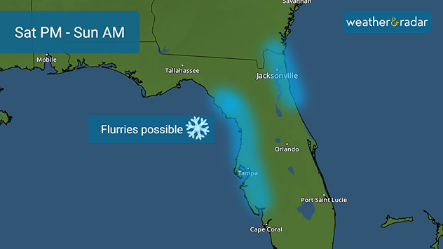
Flurries are possible Saturday night into Sunday morning along the western Florida Gulf Coast and possibly the Atlantic beaches of northeast Florida.

As arctic air invades Florida this weekend, a rare event may occur... snow! If conditions come together in just the right way, flurries may fly in the Sunshine State.

For those hoping for a snowstorm and accumulating snow in Florida, we're going to disappoint you; however, flurries are possible Saturday night into Sunday morning along the western Florida Gulf Coast and possibly the Atlantic beaches of northeast Florida.

This phenomenon is called "Gulf-effect" snow. In Florida, a “Gulf-effect” setup can occur when cold air moves over the relatively warm waters of the Gulf of Mexico. For this to happen, a long fetch of northwest winds is needed to pick up moisture, along with a sufficiently large temperature difference between the warm water and the colder air above.

With Gulf water temperatures hovering in the low 60s, and air temperatures falling to near or below-freezing on Sunday morning, there may be enough of a temperature difference to create a rain/snow mix as northwest winds kick in.

Tampa

We
81
88
Th
79
82
Fr
78
86
Sa
79
85
Su
78
79
Mo
77
86
Tu
78
93
We
80
94
Th
80
94
Fr
79
94
Sa
80
95
Su
80
94
Mo
81
94
Tu
81
92
Max (°F)
Min (°F)
moreless

Any flurries that do fall will melt quickly, but it will be a unique sight. The last measurable snow in Tampa occurred on January 19, 1977, when approximately 0.2 inches fell. While flurries are not a guarantee this weekend, the cold is, and it will linger. Our 14-day trend shows the chill lingering into early next week.

Mary Mays
More on the topic
Rip currents & safety tips. As more head to the coast. . . Saturday, July 25, 2026
rip current
Saturday, July 25, 2026

As more head to the coast

Rip currents & safety tips
High pressure & extreme heat. Why & how does it work?. . . Sunday, July 12, 2026
Sunday, July 12, 2026

Why & how does it work?

High pressure & extreme heat
How does fog form?. Multiple ways. . . Saturday, July 11, 2026
Saturday, July 11, 2026

Multiple ways

How does fog form?
All weather news
This might also interest you
Southwest heat disrupts daily flow. Closures & delays. . . Monday, July 27, 2026
Monday, July 27, 2026

Closures & delays

Southwest heat disrupts daily flow
Heat indices soaring. High humidity. . . Saturday, July 25, 2026
Saturday, July 25, 2026

High humidity

Heat indices soaring
Up to four feet of storm surge. Gulf Coast soaker. . . Tuesday, July 21, 2026
Tropical storm alerts are active in the app as Bertha continues to churn in the northern Gulf.
Tuesday, July 21, 2026

Gulf Coast soaker

Up to four feet of storm surge
All articles
Weather & Radar

Weather & Radar is also available on

Google Play StoreApp Store

Company

Contact us Privacy policy Legal info Accessibility statement

Services

Uploader

Socials

instagramfacebookthreadslinkList