Home
Weather New York
WeatherRadar
RainRadar
TemperatureRadar
WindRadar
LightningRadar
Weather News
Editor's Pick
Discover the app
Weather widget
Contact us
Apps
Career
    Home / Editor's Pick /

    Hurricane parade in the Pacific – cyclones stay out at sea

05:00 PM
September 1, 2026

Karina is very strong
Hurricane parade in the Pacific

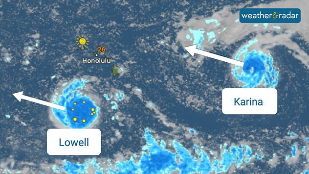
Things are hotting up in the eastern Pacific. Two tropical storms are already swirling over the warm ocean, and one of them has now gained considerable strength. Karina is already a Category 4 hurricane.

Lowell is also set to reach hurricane strength. As things stand, both storms will remain over the open Pacific and pose no direct threat to either Mexico or Hawaii.

Satellite weather map near Hawaii showing tropical systems Lowell and Karina with blue rain bands, marked centres, and arrows indicating western movement.
Hawaii is not in their path: Lowell and Karina are expected to pass by the islands, as our WeatherRadar shows.

And there’s already more on the way: a tropical depression has formed off the coast of Mexico. It is likely to strengthen into a tropical storm soon and will then be named Maria.

Maria could also develop into a hurricane by Friday. That would mean we would have three hurricanes in a row over the eastern Pacific – although, as things stand, they pose no direct threat to land.

Did you know?

El Niño often brings warmer water and more favorable wind conditions to the eastern Pacific. This makes it easier for hurricanes to form and intensify.

Weather & Radar USA editorial team
More on the topic
Hurricane Polo heads for Mexico. Severe weather risk. . . Monday, September 28, 2026
Hurricane Polo is set to make landfall in the Baja-California.
Monday, September 28, 2026

Severe weather risk

Hurricane Polo heads for Mexico
10 facts about fog. Low clouds. . . Sunday, September 27, 2026
Fog impacting the Appalachian Mountains.
Sunday, September 27, 2026

Low clouds

10 facts about fog
Hurricane Polo remains dangerous. Active Pacific. . . Thursday, September 24, 2026
Thursday, September 24, 2026

Active Pacific

Hurricane Polo remains dangerous
All weather news
This might also interest you
Moisture from Simon supercharges rain. Central US. . . Wednesday, October 14, 2026
Tropical moisture from Pacific Hurricane Simon is supercharging rainfall totals across portions of the central and southern Plains. Record-high moisture levels are being observed due to this setup.
Wednesday, October 14, 2026

Central US

Moisture from Simon supercharges rain
Isaias post-landfall impacts. Southeast soaker. . . Saturday, October 10, 2026
Southeast impacts of Isaias
Saturday, October 10, 2026

Southeast soaker

Isaias post-landfall impacts
Santa Ana winds start up. Southern California. . . Thursday, October 15, 2026
Thursday, October 15, 2026

Southern California

Santa Ana winds start up
All articles
Weather & Radar

Weather & Radar is also available on

Google Play StoreApp Store

Company

Contact us Privacy policy Legal info Accessibility statement

Services

Uploader

Socials

instagramfacebookthreadslinkList