Home
Weather New York
WeatherRadar
RainRadar
TemperatureRadar
WindRadar
LightningRadar
Weather News
Editor's Pick
Discover the app
Weather widget
Contact us
Apps
Career
    Home / Weather News /

    Daily briefing

09:00 AM
October 20, 2025

Daily briefing
Snow, heavy rain for the northern tier

A low-pressure trough dipping into the northern tier is responsible for today's active weather from the northern and central Rockies to the Great Lakes. Additionally, the rest of the autumn storm that brought damaging gusts and severe storms over the weekend is dropping rain across the Northeast before exiting into the Atlantic today. This, along with our tropical update, is available at 5 a.m. ET in our daily briefing.

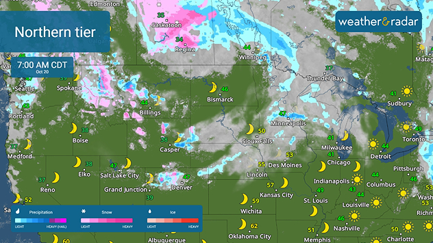
The WeatherRadar shows mountain snow and lower-elevation rain happening in the northern and central Rockies this morning, with rainfall scattered in the Upper Midwest. Today, as a low-pressure trough dips southward from Canada, we'll see rainfall spread from the High Plains to Chicago.

Northern tier activity as seen on the WeatherRadar.

Additionally, rain continues this morning from the Mid-Atlantic to the Northeast as the large autumn storm heads out to sea. Mind the WeatherRadar throughout the day to see when the umbrellas will get a break.

Temperatures will mostly be above average for the U.S. Highs in the 70s and 80s stretch from California to the Mid-Mississippi Valley and to the Southeast and Florida, with Texas heating up to possibly record-breaking 90s. The cooler upper 50s and 60s will stretch from Seattle to Chicago to Washington, D.C. and into the Northeast. Track the TemperatureRadar for your local details.

Tropical Update

We are watching a possible area of development in the Caribbean. At this time, there is only a 80 percent chance of organization over the next 7 days. We continue to monitor the tropics as the Atlantic Hurricane Season lasts until November 30.

App News

If you are (or input a location) within 5 miles of the coast, you can see the marine conditions as well as the high and low tide times, here.

Becca Parker
More on the topic
10 facts about fog. Low clouds. . . Sunday, September 27, 2026
Fog impacting the Appalachian Mountains.
Sunday, September 27, 2026

Low clouds

10 facts about fog
Hurricane Polo remains dangerous. Active Pacific. . . Thursday, September 24, 2026
Thursday, September 24, 2026

Active Pacific

Hurricane Polo remains dangerous
Hurricane Polo heads for Mexico. Severe weather risk. . . Monday, September 28, 2026
Hurricane Polo is set to make landfall in the Baja-California.
Monday, September 28, 2026

Severe weather risk

Hurricane Polo heads for Mexico
All weather news
This might also interest you
Fall fronts bring big changes. How to track them. . . Friday, October 16, 2026
Friday, October 16, 2026

How to track them

Fall fronts bring big changes
Soggy end to the weekend for some. Remnants of Isaias. . . Sunday, October 11, 2026
While Isaias may have made landfall near Destin, Fla., Friday night, the hurricane's remnants will bring a soggy end to the weekend hundreds of miles away from the point of landfall.
Sunday, October 11, 2026

Remnants of Isaias

Soggy end to the weekend for some
Moisture from Simon supercharges rain. Central US. . . Wednesday, October 14, 2026
Tropical moisture from Pacific Hurricane Simon is supercharging rainfall totals across portions of the central and southern Plains. Record-high moisture levels are being observed due to this setup.
Wednesday, October 14, 2026

Central US

Moisture from Simon supercharges rain
All articles
Weather & Radar

Weather & Radar is also available on

Google Play StoreApp Store

Company

Contact us Privacy policy Legal info Accessibility statement

Services

Uploader

Socials

instagramfacebookthreadslinkList