Home
Weather New York
WeatherRadar
RainRadar
TemperatureRadar
WindRadar
LightningRadar
Weather News
Editor's Pick
Discover the app
Weather widget
Contact us
Apps
Career
    Home / Weather News /

    Tropical Storm Edouard to bring heavy rains, surge

11:47 AM
September 1, 2026

Texas & Louisiana
9 inches of rain, 4 feet of surge

Tropical Storm Edouard will bring heavy rains and gusty winds, with flooding possible.

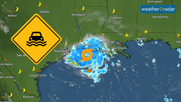
The fifth tropical storm of the Atlantic season has formed, and heavy rainfall will affect Southeast Texas and western Louisiana. The combination of as much as 9 inches of rain and up to four feet of storm surge could cause further issues.

How warm is the Gulf right now?

Sea surface temperatures are running as high as almost 90°F near the Texas and Louisiana coasts.

The WeatherRadar shows Tropical Storm Edouard continues to become better organized and will approach the Louisiana and Texas coast tonight. The storm’s center is well-defined, and while it remains over the warm waters of the Gulf of Mexico, it is likely to strengthen, possibly rapidly, before making landfall.

Storm surge of up to 4 feet is possible along the Louisiana and Southeast Texas coasts. Rainfall totals could reach as much as 9 inches in isolated areas, but most locations are expected to receive between 4 and 6 inches. Those near rivers and bayous should pay close attention, as water levels can rise quickly, potentially causing dangerous flooding.

Once Edouard makes landfall, it will weaken and lose its storm classification, but the rain will continue, and the risk of flooding will persist across inland Texas. The WindRadar indicates that the storm will be slowing down, but the WeatherRadar will continue to show active rainfall over the next several days.

Irene Sans
More on the topic
What are weather fronts?. Weather explained. . . Sunday, August 23, 2026
Image of a temperature radar showing a clear distinction between a warm and cold air mass separated by a cold front.
Sunday, August 23, 2026

Weather explained

What are weather fronts?
Meteorological vs astronomical autumn. Season start date. . . Tuesday, September 1, 2026
Tuesday, September 1, 2026

Season start date

Meteorological vs astronomical autumn
Hurricane parade in the Pacific. Karina is very strong. . Weather Videos. Tuesday, September 1, 2026
WindRadar for Friday, showing the three hurricanes – Lowell, Karina and Maria – over the Pacific.
Weather VideosTuesday, September 1, 2026

Karina is very strong

Hurricane parade in the Pacific
All weather news
This might also interest you
Why the South will sizzle. Heat wave builds. . . Wednesday, September 2, 2026
Wednesday, September 2, 2026

Heat wave builds

Why the South will sizzle
Northwest chilly showers. Autumn premiere. . . Thursday, September 3, 2026
A cooler Northwest
Thursday, September 3, 2026

Autumn premiere

Northwest chilly showers
Southwest flood risk. Brief triple-digit break. . . Monday, August 31, 2026
Desert Southwest
Monday, August 31, 2026

Brief triple-digit break

Southwest flood risk
All articles
Weather & Radar

Weather & Radar is also available on

Google Play StoreApp Store

Company

Contact us Privacy policy Legal info Accessibility statement

Services

Uploader

Socials

instagramfacebookthreadslinkList