Home
Weather New York
WeatherRadar
RainRadar
TemperatureRadar
WindRadar
LightningRadar
Weather News
Editor's Pick
Discover the app
Weather widget
Contact us
Apps
Career
    Home / Weather News /

    Daily briefing

10:00 AM
November 4, 2025

Daily briefing
Stormy Pacific Northwest

Rain and mountain snow continue for the Pacific Northwest as one storm exits and another approaches. The central U.S. will continue to see well-above-average temperatures. This, along with our tropical update, is available at 5 a.m. ET in our daily briefing.

The WeatherRadar will be active across the Pacific Northwest today as one system exits and another follows right on its heels. Between 3-5 inches of rain are possible for coastal Washington, Oregon and northern California through tomorrow.

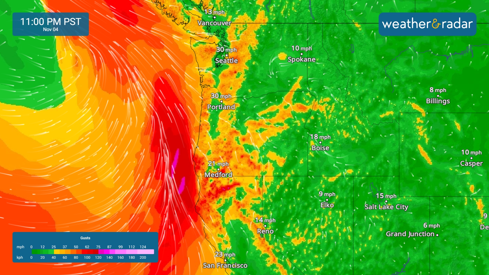
The WindRadar shows gusts exceeding 30 mph by tonight across the Pacific Northwest.
The WindRadar shows gusts exceeding 30 mph by tonight.

The WindRadar shows gusty conditions settling in across the Pacific Northwest as our next atmospheric river approaches. By tonight, wind gusts will exceed 30 mph in cities like Portland, Ore., and Seattle. Keep an eye on the timing with the WeatherRadar.

The northern Rockies will pick up a few snow showers, and the Great Lakes region will see some rain. The rest of the country remains dry, with warmer-than-average temperatures surging across the central U.S.

Temperatures will warm to the mid- and upper-80s across the Southwest, with near-record highs in cities like Denver and Amarillo. The above-average warmth will extend into the Midwest, where highs will reach the 60s.

Tropical Update

Tropical activity is not expected over the next several days. We continue to monitor the tropics as the Atlantic Hurricane Season lasts until November 30.

App News

If you are (or input a location) within 5 miles of the coast, you can see the marine conditions as well as the high and low tide times, here.

Mary Mays
More on the topic
How does fog form?. Multiple ways. . . Saturday, July 11, 2026
Saturday, July 11, 2026

Multiple ways

How does fog form?
Rip currents & safety tips. As more head to the coast. . . Saturday, July 25, 2026
rip current
Saturday, July 25, 2026

As more head to the coast

Rip currents & safety tips
Waterspouts possible, what are they?. They can be dangerous. . . Sunday, August 9, 2026
Waterspouts weatherradar.
Sunday, August 9, 2026

They can be dangerous

Waterspouts possible, what are they?
All weather news
This might also interest you
Southwest flood risk. Brief triple-digit break. . . Monday, August 31, 2026
Desert Southwest
Monday, August 31, 2026

Brief triple-digit break

Southwest flood risk
Northwest chilly showers. Autumn premiere. . . Thursday, September 3, 2026
A cooler Northwest
Thursday, September 3, 2026

Autumn premiere

Northwest chilly showers
Understanding the feels like temperature. Advanced heat measurement. . . Sunday, August 30, 2026
feels like temperature
Sunday, August 30, 2026

Advanced heat measurement

Understanding the feels like temperature
All articles
Weather & Radar

Weather & Radar is also available on

Google Play StoreApp Store

Company

Contact us Privacy policy Legal info Accessibility statement

Services

Uploader

Socials

instagramfacebookthreadslinkList