Home
Weather New York
WeatherRadar
RainRadar
TemperatureRadar
WindRadar
LightningRadar
Weather News
Editor's Pick
Discover the app
Weather widget
Contact us
Apps
Career
    Home / Weather News /

    Daily briefing

10:00 AM
October 30, 2025

Daily briefing
Nor'easter brings gusty winds, thunderstorms

A Nor'easter is bringing heavy rain, gusty winds and mountain snow from the Ohio and Tennessee valleys and Mid-Atlantic to the Northeast today. Embedded severe thunderstorms are possible, too. Additionally, a clipper system will make its way into the northern tier. This, along with our tropical update, is available at 5 a.m. ET in our daily briefing.

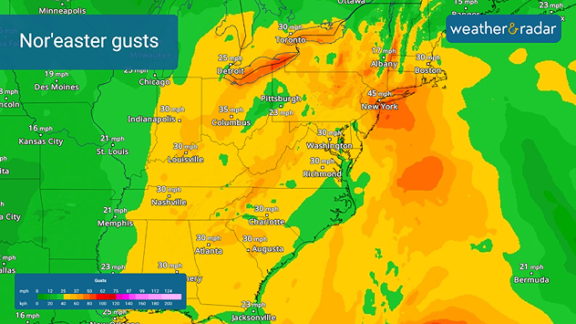
Heavy rain and gusty winds are impacting the Ohio and Tennessee valleys and the Mid-Atlantic this morning. The winds will become much more widespread throughout the morning, reaching into the Gulf Coast while rain extends southward along the Appalachian spine. Embedded, and possibly severe, thunderstorms are possible from Philadelphia through Hagerstown Md., Washington D.C., Richmond, Va., and down through the Outer Banks of North Carolina.

Gusty winds will accompany the Nor'eastern throughout the day today.
Gusty winds will accompany the Nor'easter throughout the day today.

The Nor'easter will make its way into the Northeast throughout the day, with an isolated flash flood risk in northern New Jersey through Long Island and along southwestern Connecticut. Keep an eye on the WeatherRadar throughout the day.

Isolated rain will stretch into the Dakotas and Upper Midwest for much of the day before a clipper dips in, bringing snow chances this evening and through the overnight across North Dakota. Are your vehicles prepped for snow?

The Ohio Valley and Appalachians, pockets of the Northeast and the northern tier will be in the upper 40s and 50s today, with similar highs being found in the Mountain West. Upper 50s and 60s will spread everywhere else except for the Southwest and Florida, where warmer highs in the 70s and 80s will keep things toasty.

Tropical Update

Hurricane Melissa has passed north of the Bahamas and is headed northeast toward Bermuda today. Watch it closely on the WeatherRadar.

We continue to monitor the tropics as the Atlantic Hurricane Season lasts until November 30.

App News

If you are (or input a location) within 5 miles of the coast, you can see the marine conditions as well as the high and low tide times, here.

Becca Parker
More on the topic
Super Typhoon Near the Philippines. Gusts up to 155. . . Tuesday, June 23, 2026
Tuesday, June 23, 2026

Gusts up to 155

Super Typhoon Near the Philippines
The only Blue Moon of the year rises. May astronomy outlook. . . Saturday, May 2, 2026
Saturday, May 2, 2026

May astronomy outlook

The only Blue Moon of the year rises
Record-breaking heatwave in Europe. Hotter than most of U.S.. . . Thursday, June 25, 2026
Thursday, June 25, 2026

Hotter than most of U.S.

Record-breaking heatwave in Europe
All weather news
This might also interest you
Saharan dust to reach Florida. Dry period expected. . . Tuesday, July 7, 2026
Saharan dust seen on the satllite image (right) moving westward toward Florida. Air quality impacts are expected.
Tuesday, July 7, 2026

Dry period expected

Saharan dust to reach Florida
Understanding the feels like temperature. Advanced heat measurement. . . Friday, July 3, 2026
feels like temperature
Friday, July 3, 2026

Advanced heat measurement

Understanding the feels like temperature
Turning hot this weekend. Brutal temps across West. . . Friday, July 10, 2026
Saturday & Sunday's highs
Friday, July 10, 2026

Brutal temps across West

Turning hot this weekend
All articles
Weather & Radar

Weather & Radar is also available on

Google Play StoreApp Store

Company

Contact us Privacy policy Legal info Accessibility statement

Services

Uploader

Socials

instagramfacebookthreadslinkList