Home
Weather New York
WeatherRadar
RainRadar
TemperatureRadar
WindRadar
LightningRadar
Weather News
Editor's Pick
Discover the app
Weather widget
Contact us
Apps
Career
    Home / Weather News /

    Daily briefing

09:00 AM
October 16, 2025

Daily briefing
Autumn storm impacts northern tier

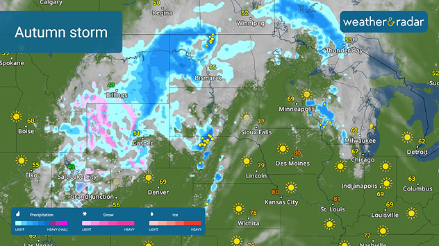
A large autumn storm continues to impact the U.S., this time bringing rain, isolated thunderstorms and mountain snow to the northern Rockies, High Plains and northern tier. This, along with our tropical update, is available at 5 a.m. ET in our daily briefing.

A large autumn storm that brought isolated severe weather to the central Rockies and High Plains overnight is making its way north and east. Mountain snow forecasts have triggered winter weather advisories in western Wyoming and heavy rainfall could cause isolated flash flooding in North Dakota today.

An autumn storm is impacting the northern tier today.

The WeatherRadar shows the low-pressure system churning from northern Utah this morning through Wyoming throughout the day, spreading mountain snow across the northern Rockies. On the warmer side of the storm, heavy rain and thunderstorms are expected in the High Plains, the northern and central Plains, as well as the Upper Midwest.

The Northeast and coastal New England will need umbrellas today, especially in Bangor and Portland, Maine, as well as Boston. Keep an eye on the WeatherRadar to get timing details.

Highs in the U.S. today will be a mix of summer and fall temperatures. Cool 50s and 60s will be found along the West Coast and into the Great Basin as well as in the Great Lakes, Ohio Valley, Mid-Atlantic and Northeast. Warmer temperatures in the 70s and 80s will be found across the central U.S., from the Plains to the mid-and lower Mississippi valleys, as well as in the Southeast and Florida.

Tropical Update

Tropical Storm Lorenzo has dissipated. No other tropical activity is expected in the Atlantic over the next 7 days.

We continue to monitor the tropics as the Atlantic Hurricane Season lasts until November 30.

App News

If you are (or input a location) within 5 miles of the coast, you can see the marine conditions as well as the high and low tide times, here.

Becca Parker
More on the topic
How does fog form?. Multiple ways. . . Saturday, July 11, 2026
Saturday, July 11, 2026

Multiple ways

How does fog form?
Meteorological vs astronomical autumn. Season start date. . . Tuesday, September 1, 2026
Tuesday, September 1, 2026

Season start date

Meteorological vs astronomical autumn
Rip currents & safety tips. As more head to the coast. . . Saturday, July 25, 2026
rip current
Saturday, July 25, 2026

As more head to the coast

Rip currents & safety tips
All weather news
This might also interest you
Understanding the feels like temperature. Advanced heat measurement. . . Sunday, August 30, 2026
feels like temperature
Sunday, August 30, 2026

Advanced heat measurement

Understanding the feels like temperature
Southwest flood risk. Brief triple-digit break. . . Monday, August 31, 2026
Desert Southwest
Monday, August 31, 2026

Brief triple-digit break

Southwest flood risk
Catch an eerie red moon. Striking view. . . Thursday, August 27, 2026
Thursday, August 27, 2026

Striking view

Catch an eerie red moon
All articles
Weather & Radar

Weather & Radar is also available on

Google Play StoreApp Store

Company

Contact us Privacy policy Legal info Accessibility statement

Services

Uploader

Socials

instagramfacebookthreadslinkList