Home
Weather New York
WeatherRadar
RainRadar
TemperatureRadar
WindRadar
LightningRadar
Weather News
Editor's Pick
Discover the app
Weather widget
Contact us
Apps
Career
    Home / Weather News /

    Daily briefing

09:00 AM
October 29, 2025

Daily briefing
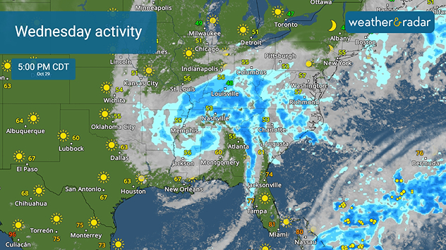
Rain, storms from Miss., Valley to Carolinas

A large storm system keeps those from the mid-Mississippi Valley to the Southeast and Mid-Atlantic under rain and clouds today. Major Hurricane Melissa made landfall in Jamaica on Tuesday and will zip over the Bahamas today. This, along with our tropical update, is available at 5 a.m. ET in our daily briefing.

A large storm system is slowing commutes along a large portion of the Mississippi Valley to the Tennessee Valley this morning, and it will slowly continue east throughout the day, impacting the Southeast and Mid-Atlantic later. Heavy rain, gusty winds and embedded thunderstorms will have the radars busy, even throughout tonight as the low starts to swing northeast.

Heavy rain and husty winds will keep the eastern half active today,

A Pacific Northwest storm will continue inland today, bringing rain and mountain snow as far east as the northern Rockies and High Plains.

High temperatures will be in the 50s and 60s for most today, with California, the Southwest and Florida staying warmer in the upper 70s and 80s. South Texas will take a notable dip in temperatures, going from the mid-to-upper 80s on Tuesday to highs in the 60s today. See the TemperatureRadar for closer details.

Tropical Update

Hurricane Melissa made landfall in Jamaica on Tuesday with sustained winds of 185 mph and higher gusts, bringing extensive, life-threatening damage. It will move across the Bahamas today as it moves northeastward. Interests in Bermuda should watch Melissa closely as it is expected to move over the island on Thursday. Watch it closely on the WeatherRadar.

We continue to monitor the tropics as the Atlantic Hurricane Season lasts until November 30.

App News

If you are (or input a location) within 5 miles of the coast, you can see the marine conditions as well as the high and low tide times, here.

Becca Parker
More on the topic
The best views of Wednesday's eclipse. Europe's sky show. . . Thursday, August 13, 2026
Solar eclipse: The sun obscured between wind turbines in Sardinia
Thursday, August 13, 2026

Europe's sky show

The best views of Wednesday's eclipse
Waterspouts possible, what are they?. They can be dangerous. . . Sunday, August 9, 2026
Waterspouts weatherradar.
Sunday, August 9, 2026

They can be dangerous

Waterspouts possible, what are they?
How does fog form?. Multiple ways. . . Saturday, July 11, 2026
Saturday, July 11, 2026

Multiple ways

How does fog form?
All weather news
This might also interest you
Days of record nighttime heat. Feeling tropical. . . Monday, August 17, 2026
Monday, August 17, 2026

Feeling tropical

Days of record nighttime heat
Gravity wave spotted on WeatherRadar. Moving into TN. . . Monday, August 17, 2026
Monday, August 17, 2026

Moving into TN

Gravity wave spotted on WeatherRadar
What to know this hurricane season. Knowledge is power. . . Sunday, August 23, 2026
Hurricanes approaching the coastline can cause extensive impacts, including flooding, even before landfall.
Sunday, August 23, 2026

Knowledge is power

What to know this hurricane season
All articles
Weather & Radar

Weather & Radar is also available on

Google Play StoreApp Store

Company

Contact us Privacy policy Legal info Accessibility statement

Services

Uploader

Socials

instagramfacebookthreadslinkList