Home
Weather New York
WeatherRadar
RainRadar
TemperatureRadar
WindRadar
LightningRadar
Weather News
Editor's Pick
Discover the app
Weather widget
Contact us
Apps
Career
    Home / Weather News /

    Daily briefing: Active West, isolated severe storms possible

10:00 AM
January 7, 2026

Daily briefing
Active West, isolated severe storms possible

The West will continue to see rain and snow as several low-pressure systems affect the region. Isolated severe weather is possible in the southern Plains today. Along the East Coast, a cold front will be exiting, but not before dropping a few rain showers and snow across the Northeast. The daily briefing is published every weekday at 5 a.m. ET.

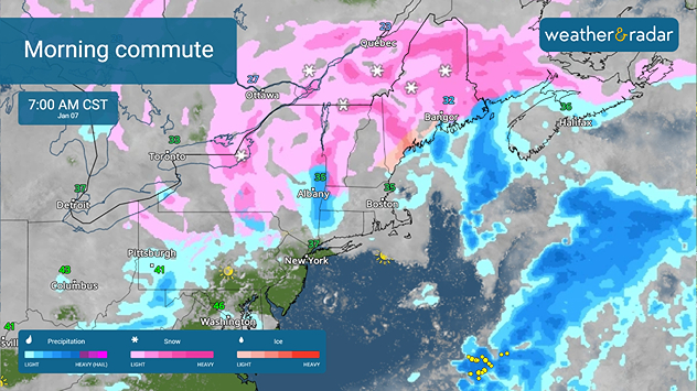
Isolated to scattered rain will zip across the East Coast with a cold front today. Snow will impact the Northeast, especially early in the day. Morning, commutes could be slow in New England.

Northeast commutes could be slow due to snow.

The WeatherRadar shows rain and mountain snow impacting the Pacific Northwest through the northern Rockies and southward into central California. Southern California and the Desert Southwest will also see early chances of rain.

This active pattern continues throughout the day, and a few thunderstorms may pop up along the Pacific Northwest Coast. Snow will move across the Great Basin and into the central and southern Rockies overnight. Have an eye on the WeatherRadar throughout the day.

Isolated severe storms are possible overnight as storms moving through the Rockies today shift into the Plains. Have your weather alerts switched on, especially from Oklahoma City to Midland, Texas.

Mild 50s and 60s will spread from the central Plains to the Mid-Atlantic, with 70s and 80s stretching across the South. A mix of 50s and 60s will be found in California and the Desert Southwest, with more fabulous 30s and 40s spreading throughout the Mountain West. The northern Plains and the Northeast will also be chilly in the 30s and 40s.

App news

New year, best weather app! Share your love for Weather & Radar with a friend or loved one.

Becca Parker
More on the topic
Super Typhoon Near the Philippines. Gusts up to 155. . . Tuesday, June 23, 2026
Tuesday, June 23, 2026

Gusts up to 155

Super Typhoon Near the Philippines
Rip currents & safety tips. As more head to the coast. . . Sunday, July 5, 2026
rip current
Sunday, July 5, 2026

As more head to the coast

Rip currents & safety tips
El Niño is gaining momentum. Temperature records?. . . Thursday, May 7, 2026
The image shows the central Pacific in a computer model. A striking feature is the ocean coloured red, which indicates very warm seawater.
Thursday, May 7, 2026

Temperature records?

El Niño is gaining momentum
All weather news
This might also interest you
Saharan dust to reach Florida. Dry period expected. . . Tuesday, July 7, 2026
Saharan dust seen on the satllite image (right) moving westward toward Florida. Air quality impacts are expected.
Tuesday, July 7, 2026

Dry period expected

Saharan dust to reach Florida
Ring of fire developing. Storms encircle heat. . . Wednesday, July 1, 2026
Wednesday, July 1, 2026

Storms encircle heat

Ring of fire developing
Tough sleeping temperatures too. Stifling hot night & day. . . Thursday, July 2, 2026
Friday's temperatures
Thursday, July 2, 2026

Stifling hot night & day

Tough sleeping temperatures too
All articles
Weather & Radar

Weather & Radar is also available on

Google Play StoreApp Store

Company

Contact us Privacy policy Legal info Accessibility statement

Services

Uploader

Socials

instagramfacebookthreadslinkList