Home
Weather New York
WeatherRadar
RainRadar
TemperatureRadar
WindRadar
LightningRadar
Weather News
Editor's Pick
Discover the app
Weather widget
Contact us
Apps
Career
    Home / Weather News /

    Southern Plains - 20 days of at least 100°F

04:36 PM
August 20, 2026

Southern Plains
20 days of at least 100°F

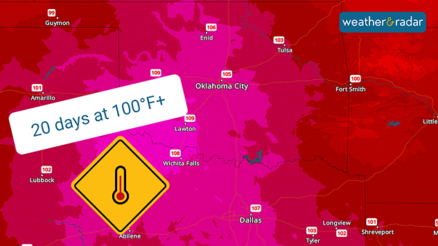
Dallas-Fort Worth has had 20 days of temperatures reaching at least 100°F this summer, with more expected.

Century-old records could fall in parts of the southern Plains as high-pressure pumps hot & humid air out of the Gulf. Multiple rounds of intense heat this summer have produced dozens of 90°F+ days, with one major city officially having 20 days at or over 100°F, with more to come.

Oklahoma City and Dallas-Fort Worth residents have been staying in the A.C. this summer thanks to several high-pressure systems setting up camp and leaving oven doors wide open. Multiple records have been broken or set, and Dallas-Fort Worth has officially had 20 days of 100°F+ heat, with the Weather & Radar app forecast detailing more for the weekend and even into the 14-day forecast period.

Oklahoma City

Th
80
104
Fr
76
103
Sa
77
105
Su
75
97
Mo
75
106
Tu
80
103
We
79
97
Th
74
96
Fr
73
100
Sa
74
103
Su
76
104
Mo
79
101
Tu
76
95
We
76
100
Max (°F)
Min (°F)
moreless

Dallas

Th
81
104
Fr
82
105
Sa
81
107
Su
82
107
Mo
85
104
Tu
82
104
We
87
103
Th
85
101
Fr
82
104
Sa
83
106
Su
83
105
Mo
84
103
Tu
82
100
We
82
100
Max (°F)
Min (°F)
moreless

Both the weather stations in Oklahoma City and Dallas-Fort Worth could break records dating back 115 years on Friday and Saturday as this round of heat overstays its welcome. The TemperatureRadar shows highs are forecast to reach past the 100-degree mark again for both cities.

Becca Parker
More on the topic
Longest day of the year is here. Summer solstice. . . Sunday, June 21, 2026
Sunday, June 21, 2026

Summer solstice

Longest day of the year is here
Super Typhoon Bavi threatens Taiwan. 155 mph winds. . Weather Videos. Wednesday, July 8, 2026
The image shows an intense tropical cyclone over the western Pacific, east of Taiwan and the Philippines. The centre of the system is depicted as a light purple and white vortex with a clearly visible eye, surrounded by a ring of red and orange areas indicating the strongest wind speeds. A white arrow marks the typhoon’s predicted track towards the north-west, in the direction of Taiwan. To the west of the storm lie the Philippines, with the cities of Manila and Cebu; to the north of these lies Taiwan, with Taipei. Further west, the Chinese coast, including Hong Kong, and parts of Vietnam can be seen. The coloured wind map shows predominantly green areas outside the storm’s core, indicating significantly weaker winds. White streamlines illustrate the typhoon’s anti-clockwise circulation in the Northern Hemisphere. The highest wind speeds are concentrated around the eye of the cyclone.
Weather VideosWednesday, July 8, 2026

155 mph winds

Super Typhoon Bavi threatens Taiwan
High pressure & extreme heat. Why & how does it work?. . . Sunday, July 12, 2026
Sunday, July 12, 2026

Why & how does it work?

High pressure & extreme heat
All weather news
This might also interest you
The South sweats for a while. 14-Day trend. . . Wednesday, August 19, 2026
Wednesday, August 19, 2026

14-Day trend

The South sweats for a while
Days of record nighttime heat. Feeling tropical. . . Monday, August 17, 2026
Monday, August 17, 2026

Feeling tropical

Days of record nighttime heat
Lala poses rare hurricane landfall. Hawaiian Islands. . . Friday, August 14, 2026
Lala is set to become a hurrricane with a possible record-making landfall on the Big Island in Hawaii.
Friday, August 14, 2026

Hawaiian Islands

Lala poses rare hurricane landfall
All articles
Weather & Radar

Weather & Radar is also available on

Google Play StoreApp Store

Company

Contact us Privacy policy Legal info Accessibility statement

Services

Uploader

Socials

instagramfacebookthreadslinkList