Home
Weather New York
WeatherRadar
RainRadar
TemperatureRadar
WindRadar
LightningRadar
Weather News
Editor's Pick
Discover the app
Weather widget
Contact us
Apps
Career
    Home / Weather News /

    Daily briefing: Busy Northwest start

10:00 AM
December 22, 2025

Daily briefing
Busy Northwest start

The Pacific Northwest and the parts of northern California cannot catch a break from the soggy weather as the shortened holiday work week kicks off. This is included in today's daily briefing published every weekday at 5 a.m. ET.

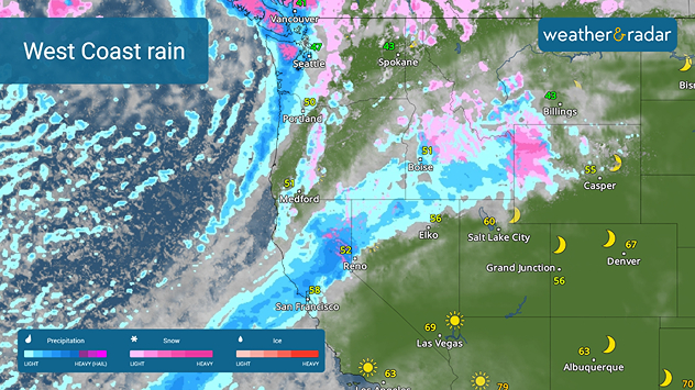
The WeatherRadar shows another major Pacific storm that roared ashore on Sunday will continue to spread heavy rain onto the West Coast. Northern California, including San Francisco, the Pacific Northwest, the northern Great Basin and the northern Rockies will all receive rain, with higher elevations receiving snow.

West Coast rain
Heavy rain moves into northern California and the Northwest.

Rain showers will also be a problem across the southern Mississippi Valley, while some wintry mix rolls across the Midwest and Great Lakes later today.

The rest of the U.S. will be quiet. The TemperatureRadar shows a winter warm-up continuing across the western and southern Plains with highs in the 70s in Denver and Dallas.

Similar reading will be found across southern Florida and the Southwest. The rest of the southern tier will be in the 60s, while the northern tier will generally be in the 40s. The Northeast and northern Plains will be the coldest spots with highs in the 20s and 30s.

App News

Finalizing holiday plans? Want to know how the Weather & Radar app can help? You can see all of our features at a glance using the Discover the App feature.

James West
More on the topic
Super Typhoon Bavi threatens Taiwan. 155 mph winds. . Weather Videos. Wednesday, July 8, 2026
The image shows an intense tropical cyclone over the western Pacific, east of Taiwan and the Philippines. The centre of the system is depicted as a light purple and white vortex with a clearly visible eye, surrounded by a ring of red and orange areas indicating the strongest wind speeds. A white arrow marks the typhoon’s predicted track towards the north-west, in the direction of Taiwan. To the west of the storm lie the Philippines, with the cities of Manila and Cebu; to the north of these lies Taiwan, with Taipei. Further west, the Chinese coast, including Hong Kong, and parts of Vietnam can be seen. The coloured wind map shows predominantly green areas outside the storm’s core, indicating significantly weaker winds. White streamlines illustrate the typhoon’s anti-clockwise circulation in the Northern Hemisphere. The highest wind speeds are concentrated around the eye of the cyclone.
Weather VideosWednesday, July 8, 2026

155 mph winds

Super Typhoon Bavi threatens Taiwan
Rip currents & safety tips. As more head to the coast. . . Sunday, July 5, 2026
rip current
Sunday, July 5, 2026

As more head to the coast

Rip currents & safety tips
Meteorological summer is here!. Bye, spring!. . . Monday, June 1, 2026
Monday, June 1, 2026

Bye, spring!

Meteorological summer is here!
All weather news
This might also interest you
Ring of fire developing. Storms encircle heat. . . Wednesday, July 1, 2026
Wednesday, July 1, 2026

Storms encircle heat

Ring of fire developing
Fireworks and Air Quality. Smoke and pollution. . . Saturday, July 4, 2026
Saturday, July 4, 2026

Smoke and pollution

Fireworks and Air Quality
100 miles, 30-degree difference. Southern California. . . Thursday, July 9, 2026
Thursday, July 9, 2026

Southern California

100 miles, 30-degree difference
All articles
Weather & Radar

Weather & Radar is also available on

Google Play StoreApp Store

Company

Contact us Privacy policy Legal info Accessibility statement

Services

Uploader

Socials

instagramfacebookthreadslinkList