Home
Weather New York
WeatherRadar
RainRadar
TemperatureRadar
WindRadar
LightningRadar
Weather News
Editor's Pick
Discover the app
Weather widget
Contact us
Apps
Career
    Home / Weather News /

    Daily briefing: Deep South severe storms, heavy rain

10:00 AM
January 9, 2026

Daily briefing
Deep South severe storms, heavy rain

A spring-like storm system will shift slightly east into the Deep South today, bringing gusty winds, tornado and hail possibilities. Heavy rain could cause scattered flooding here, too. The daily briefing is published every weekday at 5 a.m. ET.

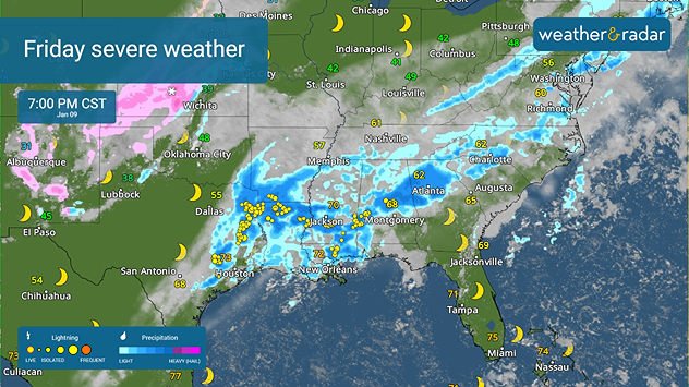
Friday's biggest story focuses on the southern severe threat, with isolated severe activity possible as far north as Evansville, Kent.

Friday's severe storm threat
The WeatherRadar shows the second round of storms across the South in the evening.

The WeatherRadar shows many across the Deep South seeing two rounds of thunderstorms, with the most severe expected during the second round, lasting into the overnight hours. Rainfall amounts up to 2.5 inches per hour are possible, especially from Lafayette and New Orleans to Chattanooga, Tenn.

The corresponding cold front triggering the storms will also extend to the Great Lakes and Northeast, bringing scattered showers today. Gusty winds are coming with it, getting as far south as the lower Ohio Valley and Mid-Atlantic. The highest gusts will be near 50 mph around the lower Great Lakes and interior Northeast, as seen on the WindRadar.

On the back/northern end of the whole storm system, snow is expected in the Midwest.

Speaking of snow, a wintry system will be sweeping across the High Plains and down to the central and southern Rockies today, moving into the Plains. We could see snow and even freezing drizzle along its cold front from the Upper Midwest down to the Texas Panhandle.

Although the northern Rockies remain snowy today, the rest of the West is getting a much-needed break in the forecast.

Because of the cold front moving east today - the one triggering the thunderstorms - many will see their highest temperatures first thing in the morning or even earlier. Chicago's high temperature will be reached just after midnight, in the unseasonably warm upper 50s and 60s. The same phenomenon will happen in places across the Midwest, like St. Louis, Mo., Grand Rapids, Mich.

Otherwise, unseasonably warm highs in the 50s and 60s will get a chance to be felt in the Ohio Valley to the Mid-Atlantic before the cold front reaches these spots. Warm 70s will spread throughout the South and Florida will see temperatures in the 80s in the afternoon.

The Northeast, the Plains and the lower elevations of the West will be in the 30s and 40s, with the California Coast and the Desert Southwest in their usual 50s and 60s.

App news

New year, best weather app! Share your love for Weather & Radar with a friend or loved one.

Becca Parker
More on the topic
Rip currents & safety tips. As more head to the coast. . . Saturday, July 25, 2026
rip current
Saturday, July 25, 2026

As more head to the coast

Rip currents & safety tips
High pressure & extreme heat. Why & how does it work?. . . Sunday, July 12, 2026
Sunday, July 12, 2026

Why & how does it work?

High pressure & extreme heat
Super Typhoon Bavi threatens Taiwan. 155 mph winds. . Weather Videos. Wednesday, July 8, 2026
The image shows an intense tropical cyclone over the western Pacific, east of Taiwan and the Philippines. The centre of the system is depicted as a light purple and white vortex with a clearly visible eye, surrounded by a ring of red and orange areas indicating the strongest wind speeds. A white arrow marks the typhoon’s predicted track towards the north-west, in the direction of Taiwan. To the west of the storm lie the Philippines, with the cities of Manila and Cebu; to the north of these lies Taiwan, with Taipei. Further west, the Chinese coast, including Hong Kong, and parts of Vietnam can be seen. The coloured wind map shows predominantly green areas outside the storm’s core, indicating significantly weaker winds. White streamlines illustrate the typhoon’s anti-clockwise circulation in the Northern Hemisphere. The highest wind speeds are concentrated around the eye of the cyclone.
Weather VideosWednesday, July 8, 2026

155 mph winds

Super Typhoon Bavi threatens Taiwan
All weather news
This might also interest you
6 riskiest places to live: hurricane edition. Do you live there?. . . Sunday, August 16, 2026
Hurricane Irma covers the entiret of Florida with Hurricane Maria coming up behind it.
Sunday, August 16, 2026

Do you live there?

6 riskiest places to live: hurricane edition
20 days of at least 100°F. Southern Plains. . . Thursday, August 20, 2026
Thursday, August 20, 2026

Southern Plains

20 days of at least 100°F
Rainfall deficit tops a foot. Southeast Florida. . . Tuesday, August 18, 2026
All heat and no rain for Southeast Florida today.
Tuesday, August 18, 2026

Southeast Florida

Rainfall deficit tops a foot
All articles
Weather & Radar

Weather & Radar is also available on

Google Play StoreApp Store

Company

Contact us Privacy policy Legal info Accessibility statement

Services

Uploader

Socials

instagramfacebookthreadslinkList