Home
Weather New York
WeatherRadar
RainRadar
TemperatureRadar
WindRadar
LightningRadar
Weather News
Editor's Pick
Discover the app
Weather widget
Contact us
Apps
Career
    Home / Weather News /

    Daily briefing: Extreme heat for Southern Plains, Four Corner rains

09:00 AM
July 21, 2025

Daily briefing
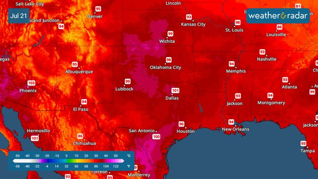
Extreme heat for Southern Plains

Temperatures soar across the Southern Plains on Monday as a high-pressure system sits over the region. The rest of the storms will swirl around the periphery of the high-pressure system. All of this, along with today's tropical outlook, is included in the daily briefing, published every weekday at 5 a.m. ET.

A high-pressure system will sit over the southern Central Plains, bringing sinking air that warms as it reaches the surface, making it feel extra toasty. The sinking air also limits the chance for storm formation across the same region. Highs in Dallas will likely surpass 100°F on Monday afternoon, while cities along the I-35 corridor through the heart of Texas will be near the triple digits. The humidity will make the temperatures feel as high as 110ºF. Please stay hydrated.

The rain will swirl across the outer edge of the high. There will be storms moving through the Four Corners and the Rockies, becoming more prolific in the afternoon. Another area where storms will be predominant will be across the Ohio River Valley through the Carolinas. The general movement of the storms will be from the northwest to the southeast, downstream. Make sure you keep the WeatherRadar handy to track the showers and storms. Stay indoors if you hear thunder or see lightning.

Tropical Update

The National Hurricane Center has officially designated a new disturbance, Invest 94L, in the Atlantic, west of the Caribbean. There is a short window of a few days where tropical development will be possible.

App news

Our Weather & Radar meteorologist will closely monitor the weather and send you personalized alerts to your phone, keeping you informed. The WeatherRadar is a great tool to take with you and track the storms.

Irene Sans
More on the topic
Rip currents & safety tips. As more head to the coast. . . Saturday, July 25, 2026
rip current
Saturday, July 25, 2026

As more head to the coast

Rip currents & safety tips
Waterspouts possible, what are they?. They can be dangerous. . . Sunday, August 9, 2026
Waterspouts weatherradar.
Sunday, August 9, 2026

They can be dangerous

Waterspouts possible, what are they?
The best views of Wednesday's eclipse. Europe's sky show. . . Thursday, August 13, 2026
Solar eclipse: The sun obscured between wind turbines in Sardinia
Thursday, August 13, 2026

Europe's sky show

The best views of Wednesday's eclipse
All weather news
This might also interest you
Be ready for tropical activity. Tips & tools. . . Saturday, August 29, 2026
Track hurricanes with the WeatherRadar
Saturday, August 29, 2026

Tips & tools

Be ready for tropical activity
Catch an eerie red moon. Striking view. . . Thursday, August 27, 2026
Thursday, August 27, 2026

Striking view

Catch an eerie red moon
Southwest flood risk. Brief triple-digit break. . . Monday, August 31, 2026
Desert Southwest
Monday, August 31, 2026

Brief triple-digit break

Southwest flood risk
All articles
Weather & Radar

Weather & Radar is also available on

Google Play StoreApp Store

Company

Contact us Privacy policy Legal info Accessibility statement

Services

Uploader

Socials

instagramfacebookthreadslinkList