Home
Weather New York
WeatherRadar
RainRadar
TemperatureRadar
WindRadar
LightningRadar
Weather News
Editor's Pick
Discover the app
Weather widget
Contact us
Apps
Career
    Home / Weather News /

    Daily briefing: Lake effect snow for the Great Lakes

10:00 AM
November 10, 2025

Daily briefing
Lake effect snow for the Great Lakes

As low pressure sends cold air deep into the South, lake effect snow gets underway across the Great Lakes. This, along with our tropical update, is available at 5 a.m. ET in our daily briefing.

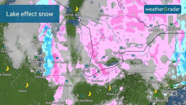
Winter has arrived —at least temporarily —across much of the eastern half of the country, with well-below-average temperatures stretching from the Great Lakes to Florida. The combination of cold air and airflow across the comparatively warmer waters of the Great Lakes will produce multiple bands of lake-effect snow.

The WeatherRadar shows lake effect snow across the Great Lakes.

Snow totals will vary, but up to a foot of accumulation is possible across the snowbelt regions. The Northeast will see chilly rain, while a dusting of snow likely across the Appalachians.

Cold air is another key component of today's weather story. Arctic air will keep highs in the 30s from the Great Lakes to the South. Cities like Birmingham, Ala., Tupelo, Miss., Athens, Ga., Oak Ridge, Tenn., and Tallahassee, Fla., may see record low highs today.

The western half of the country will see warmer and more tranquil weather. A few showers are possible in the Pacific Northwest, otherwise, it will be dry and warmer-than-average for much of the West. Temperatures in Phoenix and Los Angeles will be near 80, while Denver will see highs in the low-70s.

Tropical Update

Tropical activity is not expected over the next several days. We continue to monitor the tropics as the Atlantic Hurricane Season lasts until November 30.

App News

Getting to know your way around the Weather & Radar app just became very easy! Browse our 'Discover the App' section to learn more about the features we offer to help you make your daily weather decisions.

Mary Mays
More on the topic
Record ocean heat halting hurricanes. Strong El Niño influence. . . Sunday, September 13, 2026
A weather map shows a calm Atlantic Ocean with no hurricanes, alongside a picture of the sea.
Sunday, September 13, 2026

Strong El Niño influence

Record ocean heat halting hurricanes
Hurricane parade in the Pacific. Karina is very strong. . Weather Videos. Tuesday, September 1, 2026
WindRadar for Friday, showing the three hurricanes – Lowell, Karina and Maria – over the Pacific.
Weather VideosTuesday, September 1, 2026

Karina is very strong

Hurricane parade in the Pacific
Meteorological vs astronomical autumn. Season start date. . . Tuesday, September 1, 2026
Tuesday, September 1, 2026

Season start date

Meteorological vs astronomical autumn
All weather news
This might also interest you
Rounds of rain for Florida. Not so Sunshine State. . . Monday, October 5, 2026
While October typically marks a transition to drier weather in Florida, the first full week of the month is kicking off with heavy rain. But how much rain are we talking about?
Monday, October 5, 2026

Not so Sunshine State

Rounds of rain for Florida
First hurricane of the Atlantic season. Isaias forms. . . Thursday, October 8, 2026
After a quiet start, the Atlantic's first hurricane has finally formed. Isaias is the latest first hurricane since the satellite era began in1966. With the Gulf Coast in sight, what impacts are expected?
Thursday, October 8, 2026

Isaias forms

First hurricane of the Atlantic season
October astro outlook. Look up!. . . Saturday, October 3, 2026
Star gazing - Astro outlook
Saturday, October 3, 2026

Look up!

October astro outlook
All articles
Weather & Radar

Weather & Radar is also available on

Google Play StoreApp Store

Company

Contact us Privacy policy Legal info Accessibility statement

Services

Uploader

Socials

instagramfacebookthreadslinkList