Home
Weather New York
WeatherRadar
RainRadar
TemperatureRadar
WindRadar
LightningRadar
Weather News
Editor's Pick
Discover the app
Weather widget
Contact us
Apps
Career
    Home / Weather News /

    Daily briefing: Powerful snowstorm setting up

10:00 AM
November 28, 2025

Daily briefing
Powerful snowstorm setting up

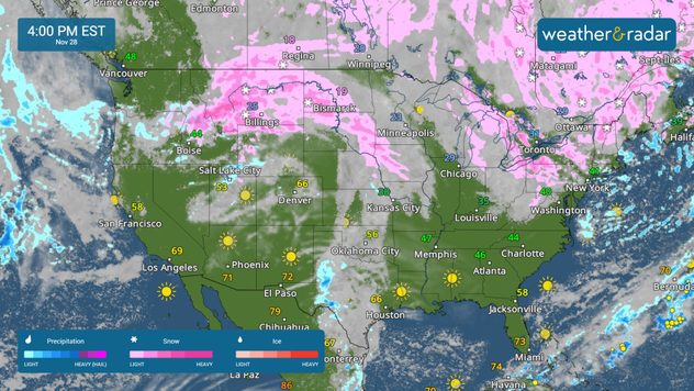
A powerful snowstorm will track across the northern Plains today, while lake-effect snow continues across the Great Lakes. This, along with our tropical update, is available at 5 a.m. ET in our daily briefing.

A powerful snowstorm is just getting started across the northern Plains today, bringing heavy snow from Billings, Mont., to Bismarck, N.D. By this evening, snow showers will spread into the Upper Midwest, with cities like Minneapolis and Des Moines, Iowa, getting in on the action. For those with Black Friday plans, it's a good idea to check the WeatherRadar before shopping.

The WeatherRadar shows more lake-effect snow for the Great Lakes, and a potent snow storm over the northern Plains.

Lake-effect snow will also continue today across parts of the Great Lakes. Once more, snow showers are expected in Cleveland, Erie, Pa., and Syracuse, N.Y. A few rain showers will dot the coastal Northeast. Chilly and blustery conditions are also forecast for the Northeast, with gusts in excess of 30 mph in Philadelphia, New York City and Boston.

The TemperatureRadar shows warm and pleasant conditions across the West, Southwest and southern Plains, where highs stay in the 60s and 70s. Chilly highs in the 20s and 30s will stretch across the northern Plains and Great Lakes, with 30s in the Ohio Valley.

Tropical Update

Tropical activity is not expected over the next several days. We continue to monitor the tropics as the Atlantic Hurricane Season lasts until November 30.

App News

Getting to know your way around the Weather & Radar app just became very easy! Browse our 'Discover the App' section to learn more about the features we offer to help you make your daily weather decisions.

Mary Mays
More on the topic
Hurricane Polo remains dangerous. Active Pacific. . . Thursday, September 24, 2026
Thursday, September 24, 2026

Active Pacific

Hurricane Polo remains dangerous
Hurricane Polo heads for Mexico. Severe weather risk. . . Monday, September 28, 2026
Hurricane Polo is set to make landfall in the Baja-California.
Monday, September 28, 2026

Severe weather risk

Hurricane Polo heads for Mexico
Meteorological vs astronomical autumn. Season start date. . . Tuesday, September 1, 2026
Tuesday, September 1, 2026

Season start date

Meteorological vs astronomical autumn
All weather news
This might also interest you
Flooding rains before the hurricane. Gulf Coast. . . Wednesday, October 7, 2026
Wednesday, October 7, 2026

Gulf Coast

Flooding rains before the hurricane
First tropical storm since the 90s?. Southern California. . . Friday, October 9, 2026
Friday, October 9, 2026

Southern California

First tropical storm since the 90s?
October astro outlook. Look up!. . . Saturday, October 3, 2026
Star gazing - Astro outlook
Saturday, October 3, 2026

Look up!

October astro outlook
All articles
Weather & Radar

Weather & Radar is also available on

Google Play StoreApp Store

Company

Contact us Privacy policy Legal info Accessibility statement

Services

Uploader

Socials

instagramfacebookthreadslinkList