Home
Weather New York
WeatherRadar
RainRadar
TemperatureRadar
WindRadar
LightningRadar
Weather News
Editor's Pick
Discover the app
Weather widget
Contact us
Apps
Career
    Home / Weather News /

    Daily briefing - Staying busy across northern tier

10:00 AM
December 10, 2025

Daily briefing
Staying busy across northern tier

The U.S. northern tier from the Northwest to the Northeast will have the most active weather today as several winter systems roll through. The rest of the U.S. will be quiet. This is included in today's daily briefing, published every weekday at 5 a.m. ET.

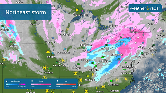
A quick-moving winter storm is rolling across the central and eastern Great Lakes and into the Northeast today. The WeatherRadar shows it bringing a wet snow to the Great Lakes, the northern Appalachians and the interior Northeast. Rain will move across the Ohio Valley and the I-95 corridor later today.

Northeast winter system
A quick-moving system will move across the Northeast and Mid-Atlantic.

In the wake of this system, a reinforcing shot of Arctic air will dive across the northern Plains and the Midwest. The TemperatureRadar shows today's highs will be in teens and 20s across the northern Plains and Midwest, but these will be early in the day as the cold air causes afternoon temperatures to plummet. Tonight's lows will be in the single digits to near zero.

The Northwest will remain busy today, too. Another wave of moisture arriving off the Pacific will bring heavy rain to the Northwest and northern Rockies, with snow falling in the highest elevations of the Cascades and northern Rockies.

The rest of the West, the southern Rockies, southern Plains, South and Southeast will be sunny today. Highs will be in the 50s and 60s across the southern tier, with a few 70s in southern California, Texas and southern Florida.

App News

Want to know everything about the Weather & Radar app? You can see all of our features at a glance using the Discover the App feature.

James West
More on the topic
Meteorological vs astronomical autumn. Season start date. . . Tuesday, September 1, 2026
Tuesday, September 1, 2026

Season start date

Meteorological vs astronomical autumn
The average first frosts in the U.S.. Meteorological autumn. . . Sunday, October 4, 2026
First frosts can begin in September as autumn temps move in.
Sunday, October 4, 2026

Meteorological autumn

The average first frosts in the U.S.
Hurricane Polo remains dangerous. Active Pacific. . . Thursday, September 24, 2026
Thursday, September 24, 2026

Active Pacific

Hurricane Polo remains dangerous
All weather news
This might also interest you
Flooding rains before the hurricane. Gulf Coast. . . Wednesday, October 7, 2026
Wednesday, October 7, 2026

Gulf Coast

Flooding rains before the hurricane
Autumn foliage: weather's impact. Leaf-peeping season!. . . Sunday, October 4, 2026
Cool nights can help intensify autumn foliage color!
Sunday, October 4, 2026

Leaf-peeping season!

Autumn foliage: weather's impact
40-degree difference over 101 miles. Eureka to Redding. . . Tuesday, October 6, 2026
Tuesday, October 6, 2026

Eureka to Redding

40-degree difference over 101 miles
All articles
Weather & Radar

Weather & Radar is also available on

Google Play StoreApp Store

Company

Contact us Privacy policy Legal info Accessibility statement

Services

Uploader

Socials

instagramfacebookthreadslinkList