Home
Weather New York
WeatherRadar
RainRadar
TemperatureRadar
WindRadar
LightningRadar
Weather News
Editor's Pick
Discover the app
Weather widget
Contact us
Apps
Career
    Home / Weather News /

    Daily briefing: Stormy Northwest and Northeast

10:00 AM
November 5, 2025

Daily briefing
Stormy Northwest and Northeast

Two storm systems will bookend the U.S. today, bringing rain and snow to the Northwest and Northeast. Well-above-average temperatures continue for much of the country. This, along with our tropical update, is available at 5 a.m. ET in our daily briefing.

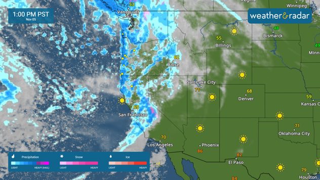
The WeatherRadar will be active across the Pacific Northwest once again as another atmospheric river brings heavy rain, wind and mountain snow across portions of California, Oregon and Washington. A few storms along the Pacific Northwest coast may be strong, with damaging winds, hail and an isolated tornado possible in cities like Portland, Ore., and Eureka, Calif.

The WeatherRadar shows the potential for strong storms along the Pacific Northwest coast.

The WindRadar shows gusty conditions settling in across the Pacific Northwest as our next atmospheric river approaches. Wind gusts will exceed 30 mph in cities like Seattle, Medford, Ore., and Redding, Calif., throughout the day.

Parts of the Northeast and New England will see blustery conditions as a quick-moving low moves into the region. This system will bring scattered showers and high-elevation snow, as well as wind gusts upwards of 40 mph.

Temperatures will warm to the mid- and upper-80s across the Southwest, and 60s and 70s across much of the Southeast.

Tropical Update

Tropical activity is not expected over the next several days. We continue to monitor the tropics as the Atlantic Hurricane Season lasts until November 30.

App News

If you are (or input a location) within 5 miles of the coast, you can see the marine conditions as well as the high and low tide times, here.

Mary Mays
More on the topic
The image shows the central Pacific in a computer model. A striking feature is the ocean coloured red, which indicates very warm seawater.
Thursday, May 7, 2026

Temperature records?

El Niño is gaining momentum
Saturday, May 2, 2026

May astronomy outlook

The only Blue Moon of the year rises
A harbour in Crete with a reddish-brown, overcast sky
Saturday, April 4, 2026

Blood red skies

Dust storm in Crete
All weather news
This might also interest you
Wednesday, May 20, 2026

Texas, South & East

WeatherRadar shows heavy rains
Saturday, May 23, 2026

Flood safety

Useful tips when driving in the rain
Thursday, May 21, 2026

Stay tuned!

Below-normal hurricane season possible
All articles
Weather & Radar

Weather & Radar is also available on

Google Play StoreApp Store

Company

Contact us Privacy policy Legal info Accessibility statement

Services

Uploader

Socials

instagramfacebookthreadslinkList