Home
Weather New York
WeatherRadar
RainRadar
TemperatureRadar
WindRadar
LightningRadar
Weather News
Editor's Pick
Discover the app
Weather widget
Contact us
Apps
Career
    Home / Weather News /

    Daily briefing: Stormy southern Plains

10:00 AM
November 20, 2025

Daily briefing
Stormy southern Plains

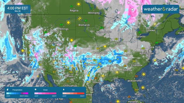
An active forecast is in play for much of the country, with wet weather stretching from California to Kentucky. This, along with our tropical update, is available at 5 a.m. ET in our daily briefing.

The WeatherRadar shows an active pattern today, with rain extending from California to Tennessee and Kentucky. Showers and mountain snow will continue to impact parts of California, Nevada and Oregon today as another Pacific system continues to move in.

The WeatherRadar shows showers and storms across much of the Southern Tier.

Low pressure will track from the Southwest to the southern Plains, bringing the risk of strong storms and flash flooding from Texas into the Mississippi River Valley. Today's flood threat extends from south Texas to the Tennessee Valley, and includes cities such as Austin and San Antonio, Texas, Fort Smith, Ark., and Springfield, Ill.

Strong storms are possible across portions of Central Texas, eastern Oklahoma and northwestern Arkansas. Damaging winds, hail and isolated tornadoes are possible today.

Unseasonably warm temperatures continue across the Southeast, where record highs are possible in Jackson, Miss., Birmingham, Ala., Atlanta and Tampa. Cooler-than-average highs in the 50s and 60s will stick around across the West and Southwest, while warmer-than-average temperatures in the 40s, 50s, and 60s extend up into the Midwest, Great Lakes and northern Plains.

Tropical Update

Tropical activity is not expected over the next several days. We continue to monitor the tropics as the Atlantic Hurricane Season lasts until November 30.

App News

Getting to know your way around the Weather & Radar app just became very easy! Browse our 'Discover the App' section to learn more about the features we offer to help you make your daily weather decisions.

Mary Mays
More on the topic
How does fog form?. Multiple ways. . . Saturday, July 11, 2026
Saturday, July 11, 2026

Multiple ways

How does fog form?
High pressure & extreme heat. Why & how does it work?. . . Sunday, July 12, 2026
Sunday, July 12, 2026

Why & how does it work?

High pressure & extreme heat
Europe: Warmest June on record. Warm waters too. . . Friday, July 10, 2026
The record-breaking heatwave in June has made climate history in Western Europe.
Friday, July 10, 2026

Warm waters too

Europe: Warmest June on record
All weather news
This might also interest you
Gravity wave clouds explained. The ideal conditions. . . Saturday, August 22, 2026
Saturday, August 22, 2026

The ideal conditions

Gravity wave clouds explained
6 riskiest places to live: hurricane edition. Do you live there?. . . Sunday, August 16, 2026
Hurricane Irma covers the entiret of Florida with Hurricane Maria coming up behind it.
Sunday, August 16, 2026

Do you live there?

6 riskiest places to live: hurricane edition
Gravity wave spotted on WeatherRadar. Moving into TN. . . Monday, August 17, 2026
Monday, August 17, 2026

Moving into TN

Gravity wave spotted on WeatherRadar
All articles
Weather & Radar

Weather & Radar is also available on

Google Play StoreApp Store

Company

Contact us Privacy policy Legal info Accessibility statement

Services

Uploader

Socials

instagramfacebookthreadslinkList