Home
Weather New York
WeatherRadar
RainRadar
TemperatureRadar
WindRadar
LightningRadar
Weather News
Editor's Pick
Discover the app
Weather widget
Contact us
Apps
Career
    Home / Weather News /

    Dangerous Memorial Day heat wave for Gulf States: Record temperatures expected

08:32 PM
May 23, 2024

Record temperatures
Dangerous heat for Memorial Day weekend

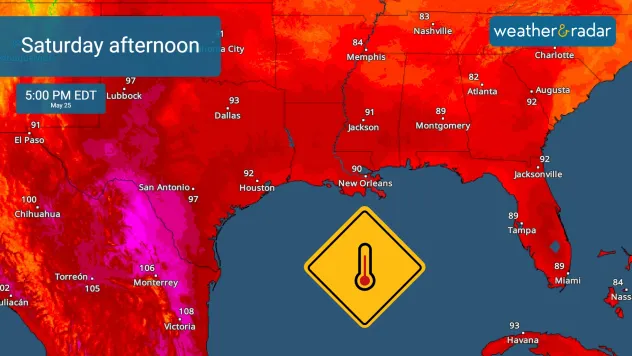
TemperatureRadar shows a swelting Saturday afternoon
TemperatureRadar shows a swelting Saturday afternoon across portions of the southern Plains and Southeast.

Gulf states are bracing for a sweltering Memorial Day weekend, with record-breaking temperatures and perilously high "feels like" temperatures anticipated.

As we approach the holiday, the Gulf Coast—from Texas to Florida—will experience escalating heat levels. Alongside this, abundant moisture will keep overnight temperatures uncomfortably high, providing little to no relief.

South Texas is set to bear the worst of this heatwave, with feels like temperatures expected to soar between 110-120°F. Laredo, Kingsville, Alice, and Cotulla are predicted to be among the hottest spots from Friday through Monday.

Know the difference

While the heat index measures how hot it feels by considering temperature and humidity, the feels like temperature also factors in wind and cloud cover, providing a more comprehensive understanding of how hot it truly feels outside.

The early season heatwave will also grip the southern Mississippi Valley and Florida. Louisiana, Mississippi, Alabama, Georgia, and Florida are facing a major to extreme heat risk, rated levels 3 to 4 out of 4, throughout the weekend. Cities like Baton Rouge and New Orleans in Louisiana and Mobile and Jackson in Mississippi will see overnight temperatures barely dip below the upper 70s.

In southern Florida and southern Texas, temperatures are unlikely to fall below the 80-degree mark.

The intense heat will persist across the region into early next week, although some relief is expected by midweek with the arrival of a cold front. Stay updated with the latest temperature changes on our interactive TemperatureRadar and make sure to keep an eye out for those feels like temperature on our app.

Federico Di Catarina
More on the topic
Hawaii's second 2026 hurricane impact. Hurricane Lowell. . . Tuesday, September 8, 2026
Tuesday, September 8, 2026

Hurricane Lowell

Hawaii's second 2026 hurricane impact
How does fog form?. Multiple ways. . . Saturday, September 12, 2026
Saturday, September 12, 2026

Multiple ways

How does fog form?
Hurricane Polo remains dangerous. Active Pacific. . . Thursday, September 24, 2026
Thursday, September 24, 2026

Active Pacific

Hurricane Polo remains dangerous
All weather news
This might also interest you
October astro outlook. Look up!. . . Saturday, October 3, 2026
Star gazing - Astro outlook
Saturday, October 3, 2026

Look up!

October astro outlook
High winds whip East Coast. Nor'easter spins offshore. . . Friday, September 25, 2026
Friday, September 25, 2026

Nor'easter spins offshore

High winds whip East Coast
Useful tips when driving in the rain. Flood safety. . . Saturday, October 3, 2026
Saturday, October 3, 2026

Flood safety

Useful tips when driving in the rain
All articles
Weather & Radar

Weather & Radar is also available on

Google Play StoreApp Store

Company

Contact us Privacy policy Legal info Accessibility statement

Services

Uploader

Socials

instagramfacebookthreadslinkList