Home
Weather New York
WeatherRadar
RainRadar
TemperatureRadar
WindRadar
LightningRadar
Weather News
Editor's Pick
Discover the app
Weather widget
Contact us
Apps
Career
    Home / Weather News /

    Day 3 without power: South recovers from ice slowly

06:15 PM
January 27, 2026

Day 3 without power
South recovers from ice slowly

The massive winter storm that brought snow, sleet and ice from Texas to New England over the past three days has departed, leaving a giant mess of snow and ice. Thawing will be slow as arctic air lingers all week.

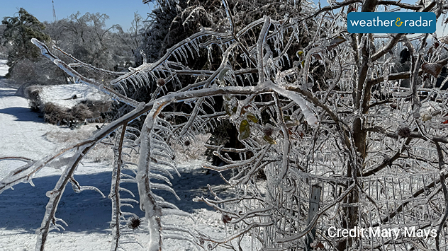
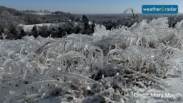
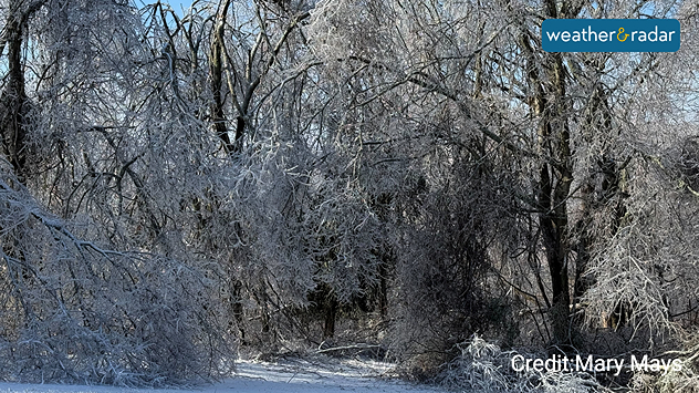
Hardest hit by the storm was parts of northeastern Texas, northern Mississippi and central Tennessee. An ice storm brought more than an inch of ice, causing massive power outages and tree damage. Around Nashville, more than 175,000 customers were still without power Tuesday morning. Mississippi and Louisiana are reporting more than 100,000 power, too.

1/5

The photos and videos above are from Weather & Radar meteorologist, Mary Mays. She has been without power since early Sunday, just outside Nashville. Nighttime temperatures throughout the South dropped into the teens, with afternoon highs only in the 20s on Monday.

Highs will finally rise above freezing today, which will help with thawing and recovery efforts. However, this will be short-lived as a fresh batch of arctic air will dive back across the South and Southeast tonight. The TemperatureRadar shows lows again dropping into the teens across the Mid-South and the central Mississippi and Tennessee valleys.

This frigid pattern seen across the Plains, Midwest, Northeast, Mid-Atlantic and into the South and Southeast will continue through the end of the week, with sub-zero readings expected early Friday throughout the Midwest and interior Northeast.

James West
More on the topic
Super Typhoon Near the Philippines. Gusts up to 155. . . Tuesday, June 23, 2026
Tuesday, June 23, 2026

Gusts up to 155

Super Typhoon Near the Philippines
How does fog form?. Multiple ways. . . Saturday, July 11, 2026
Saturday, July 11, 2026

Multiple ways

How does fog form?
Super Typhoon Bavi threatens Taiwan. 155 mph winds. . Weather Videos. Wednesday, July 8, 2026
The image shows an intense tropical cyclone over the western Pacific, east of Taiwan and the Philippines. The centre of the system is depicted as a light purple and white vortex with a clearly visible eye, surrounded by a ring of red and orange areas indicating the strongest wind speeds. A white arrow marks the typhoon’s predicted track towards the north-west, in the direction of Taiwan. To the west of the storm lie the Philippines, with the cities of Manila and Cebu; to the north of these lies Taiwan, with Taipei. Further west, the Chinese coast, including Hong Kong, and parts of Vietnam can be seen. The coloured wind map shows predominantly green areas outside the storm’s core, indicating significantly weaker winds. White streamlines illustrate the typhoon’s anti-clockwise circulation in the Northern Hemisphere. The highest wind speeds are concentrated around the eye of the cyclone.
Weather VideosWednesday, July 8, 2026

155 mph winds

Super Typhoon Bavi threatens Taiwan
All weather news
This might also interest you
Up to four feet of storm surge. Gulf Coast soaker. . . Tuesday, July 21, 2026
Tropical storm alerts are active in the app as Bertha continues to churn in the northern Gulf.
Tuesday, July 21, 2026

Gulf Coast soaker

Up to four feet of storm surge
Dry vegetation, low humidity and winds. The perfect fire recipe. . . Sunday, July 26, 2026
Sunday, July 26, 2026

The perfect fire recipe

Dry vegetation, low humidity and winds
Multi-day rain event ends soon. Southeast U.S.. . . Friday, July 24, 2026
Friday, July 24, 2026

Southeast U.S.

Multi-day rain event ends soon
All articles
Weather & Radar

Weather & Radar is also available on

Google Play StoreApp Store

Company

Contact us Privacy policy Legal info Accessibility statement

Services

Uploader

Socials

instagramfacebookthreadslinkList