Home
Weather New York
WeatherRadar
RainRadar
TemperatureRadar
WindRadar
LightningRadar
Weather News
Editor's Pick
Discover the app
Weather widget
Contact us
Apps
Career
    Home / Weather News /

    Deadly tornado outbreak continues

11:52 AM
April 3, 2025

Significant damage
Deadly tornado outbreak continues

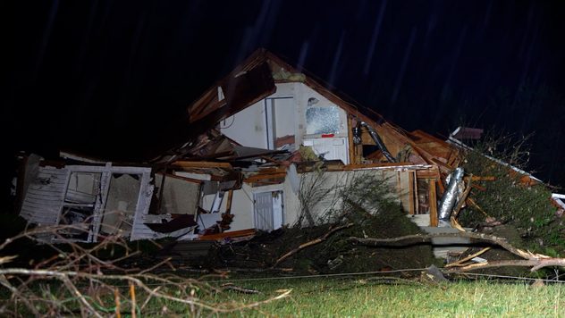
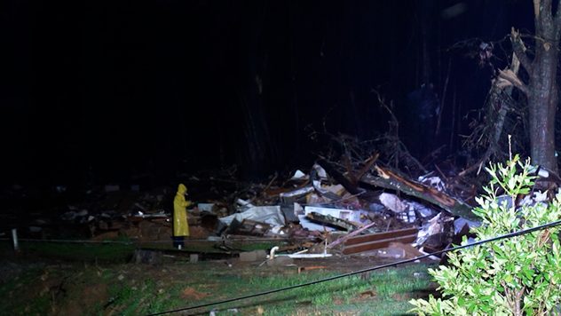
At least 28 tornadoes were reported on Wednesday as a powerful storm system ripped across the lower Ohio Valley and Mid-South. Violent tornadoes led to significant damage in Selmer, Tenn., and Lake City, Ark.

It was a frightening night for millions across the Mid-South and lower Ohio Valley as nighttime tornado-warned storms ripped through the region. At least 28 tornadoes were reported across Missouri, Arkansas, Illinois, Tennessee and Kentucky.

Homes were torn apart, and vehicles twisted into trees in Lake City, Ark., and Selmer, Tenn. The WeatherRadar remains active, with more severe weather expected on Thursday.

1/9

At least four people were killed by severe weather in Tennessee, and dozens were injured across the Mid-South and lower Ohio Valley. Another round of severe weather is expected today, along with an exceptional risk of flash flooding.

The Nashville metro woke up to tornado sirens and strong storms. Heavy rain is already leading to flash flooding across the area, making for a potentially dangerous morning commute. Learn more about the potentially historic flood threat in the Breakfast Brief.

Mary Mays
More on the topic
Waterspouts possible, what are they?. They can be dangerous. . . Sunday, August 9, 2026
Waterspouts weatherradar.
Sunday, August 9, 2026

They can be dangerous

Waterspouts possible, what are they?
What are weather fronts?. Weather explained. . . Sunday, August 23, 2026
Image of a temperature radar showing a clear distinction between a warm and cold air mass separated by a cold front.
Sunday, August 23, 2026

Weather explained

What are weather fronts?
Super Typhoon Bavi threatens Taiwan. 155 mph winds. . Weather Videos. Wednesday, July 8, 2026
The image shows an intense tropical cyclone over the western Pacific, east of Taiwan and the Philippines. The centre of the system is depicted as a light purple and white vortex with a clearly visible eye, surrounded by a ring of red and orange areas indicating the strongest wind speeds. A white arrow marks the typhoon’s predicted track towards the north-west, in the direction of Taiwan. To the west of the storm lie the Philippines, with the cities of Manila and Cebu; to the north of these lies Taiwan, with Taipei. Further west, the Chinese coast, including Hong Kong, and parts of Vietnam can be seen. The coloured wind map shows predominantly green areas outside the storm’s core, indicating significantly weaker winds. White streamlines illustrate the typhoon’s anti-clockwise circulation in the Northern Hemisphere. The highest wind speeds are concentrated around the eye of the cyclone.
Weather VideosWednesday, July 8, 2026

155 mph winds

Super Typhoon Bavi threatens Taiwan
All weather news
This might also interest you
20 days of at least 100°F. Southern Plains. . . Thursday, August 20, 2026
Thursday, August 20, 2026

Southern Plains

20 days of at least 100°F
Rainfall deficit tops a foot. Southeast Florida. . . Tuesday, August 18, 2026
All heat and no rain for Southeast Florida today.
Tuesday, August 18, 2026

Southeast Florida

Rainfall deficit tops a foot
6 riskiest places to live: hurricane edition. Do you live there?. . . Sunday, August 16, 2026
Hurricane Irma covers the entiret of Florida with Hurricane Maria coming up behind it.
Sunday, August 16, 2026

Do you live there?

6 riskiest places to live: hurricane edition
All articles
Weather & Radar

Weather & Radar is also available on

Google Play StoreApp Store

Company

Contact us Privacy policy Legal info Accessibility statement

Services

Uploader

Socials

instagramfacebookthreadslinkList