Home
Weather New York
WeatherRadar
RainRadar
TemperatureRadar
WindRadar
LightningRadar
Weather News
Editor's Pick
Discover the app
Weather widget
Contact us
Apps
Career
    Home / Weather News /

    Drought relief: Heavy rain hits Sunshine State

08:48 PM
May 27, 2026

Drought relief
Heavy rain hits Sunshine State

Heavy, widespread rain is expected to hit Florida in several waves starting Thursday.

Florida will be under a blanket of moisture, increasing the risk of showers and thunderstorms across the state. The western part of the Panhandle will continue to see rain as conditions remain highly unstable due to the arrival of another trough, which will bring intermittent showers throughout the day.

1/1
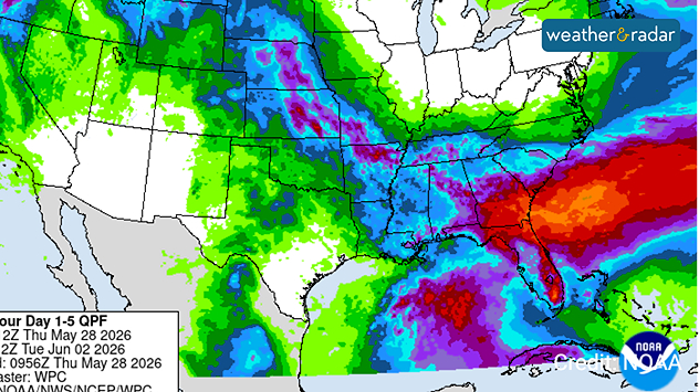
Total rainfall from Thursday through Tuesday night

The southerly flow will continue to bring moisture to Florida, and as the trough moves in from the west, showers will become more widespread on Thursday, covering the state. As the day warms up—with temperatures remaining in the 90s—thunderstorms will develop in the afternoon across the peninsula.

The risk of flash flooding will be concentrated in the southeast, from Palm Bay to Miami, covering the entire metropolitan and densely populated area of South Florida. Although it won’t rain all day, the downpours could be torrential, resulting in high rainfall totals over a short period, so avoid driving through flooded streets or areas because the water may be deeper than expected. Rainfall totals from Thursday through early next week could range from 2 to 3 inches, with isolated areas seeing more than 5 inches.

Moisture will continue to move in from the Gulf of Mexico as the week comes to a close, and it’s very likely that intense, widespread downpours will return just in time for the weekend, when the risk of heavy rain will rise again in parts of Florida—and possibly the risk of flooding as well. We’ll be keeping a close eye on these weather systems and will provide updates. Don’t forget to track the storms on our app with the Weather Radar.

Irene Sans
More on the topic
Meteorological vs astronomical autumn. Season start date. . . Tuesday, September 1, 2026
Tuesday, September 1, 2026

Season start date

Meteorological vs astronomical autumn
Hurricane Polo heads for Mexico. Severe weather risk. . . Monday, September 28, 2026
Hurricane Polo is set to make landfall in the Baja-California.
Monday, September 28, 2026

Severe weather risk

Hurricane Polo heads for Mexico
The average first frosts in the U.S.. Meteorological autumn. . . Sunday, October 4, 2026
First frosts can begin in September as autumn temps move in.
Sunday, October 4, 2026

Meteorological autumn

The average first frosts in the U.S.
All weather news
This might also interest you
Tropical moisture meets cold air. First snow of the season. . . Saturday, October 10, 2026
Saturday, October 10, 2026

First snow of the season

Tropical moisture meets cold air
First hurricane of the Atlantic season. Isaias forms. . . Thursday, October 8, 2026
After a quiet start, the Atlantic's first hurricane has finally formed. Isaias is the latest first hurricane since the satellite era began in1966. With the Gulf Coast in sight, what impacts are expected?
Thursday, October 8, 2026

Isaias forms

First hurricane of the Atlantic season
Be ready for tropical activity. Tips & tools. . . Wednesday, October 7, 2026
Track hurricanes with the WeatherRadar
Wednesday, October 7, 2026

Tips & tools

Be ready for tropical activity
All articles
Weather & Radar

Weather & Radar is also available on

Google Play StoreApp Store

Company

Contact us Privacy policy Legal info Accessibility statement

Services

Uploader

Socials

instagramfacebookthreadslinkList