Home
Weather New York
WeatherRadar
RainRadar
TemperatureRadar
WindRadar
LightningRadar
Weather News
Editor's Pick
Discover the app
Weather widget
Contact us
Apps
Career
    Home / Editor's Pick /

    Early hurricane season? This is what we are monitoring

02:24 PM
May 22, 2023

Early hurricane season?
This is what we are monitoring

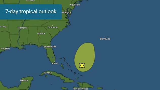
Possible formation in the next 7 days.

The same area that had a 10 percent chance for tropical development near the Bahamas during the next 7 days, is now without a chance to develop as wind shear got the best of it.. or the little best it had. But there is another area that could develop later on this week. If a tropical system were to develop before June 1, it would officially mark an early start to the hurricane season.

As mentioned on Monday morning, the broad area of low-pressure was impacted by wind shear and now it has no chance to develop into a tropical system. The cluster of thunderstorms is generally moving to the north-northeast between 5 to 10 mph. Bermuda will likely be the only piece of land that will get thunderstorms from this system as it drifts to the northeast further in the coming days.

What's happening?

A cold front will be slowly exiting the east coast of the U.S. and another low-pressure system forming, along with a front, move over Florida. This is what prevents the broad low-pressure area from moving toward the U.S. and also prevents it from developing as wind shear will continue to increase.

Later this week.

Looking at longer-range models, there will be another low-pressure area forming near the Southeast coast of the United States. By the end of the week or the weekend, conditions will be more favorable for development as wind shear will be in a downward trend as a high-pressure system builds over the northeastern portion of the U.S. We will be monitoring this possible development closely.

Irene Sans
More on the topic
The average first frosts in the U.S.. Meteorological autumn. . . Sunday, October 4, 2026
First frosts can begin in September as autumn temps move in.
Sunday, October 4, 2026

Meteorological autumn

The average first frosts in the U.S.
Hurricane Polo heads for Mexico. Severe weather risk. . . Monday, September 28, 2026
Hurricane Polo is set to make landfall in the Baja-California.
Monday, September 28, 2026

Severe weather risk

Hurricane Polo heads for Mexico
Record ocean heat halting hurricanes. Strong El Niño influence. . . Sunday, September 13, 2026
A weather map shows a calm Atlantic Ocean with no hurricanes, alongside a picture of the sea.
Sunday, September 13, 2026

Strong El Niño influence

Record ocean heat halting hurricanes
All weather news
This might also interest you
Be ready for tropical activity. Tips & tools. . . Wednesday, October 7, 2026
Track hurricanes with the WeatherRadar
Wednesday, October 7, 2026

Tips & tools

Be ready for tropical activity
October astro outlook. Look up!. . . Saturday, October 3, 2026
Star gazing - Astro outlook
Saturday, October 3, 2026

Look up!

October astro outlook
Flooding rains before the hurricane. Gulf Coast. . . Wednesday, October 7, 2026
Wednesday, October 7, 2026

Gulf Coast

Flooding rains before the hurricane
All articles
Weather & Radar

Weather & Radar is also available on

Google Play StoreApp Store

Company

Contact us Privacy policy Legal info Accessibility statement

Services

Uploader

Socials

instagramfacebookthreadslinkList