Home
Weather New York
WeatherRadar
RainRadar
TemperatureRadar
WindRadar
LightningRadar
Weather News
Editor's Pick
Discover the app
Weather widget
Contact us
Apps
Career
    Home / Weather News /

    El Niño ends! La Niña on the way next

11:00 PM
June 14, 2024

La Niña next?
El Niño ends, what to expect

El Niño

Big changes are on the way for global weather patterns as El Niño officially comes to an end.

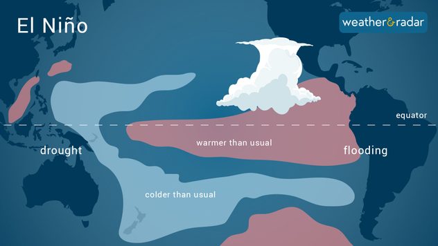
El Niño, a climate pattern marked by warmer-than-average temperatures in the tropical Pacific Ocean, has been in place since early summer 2023. This nearly year-long pattern is finally loosening its grip on the weather pattern, and big changes are on the way.

Privacy policy

This past year's El Niño was one of the strongest on record and helped boost temperatures during the hottest year on record. This El Niño was so strong that it reached rare "super El Niño" territory. From November to January, water temperatures in the tropical Pacific Ocean were 2 degrees Celsius warmer than average, a threshold that has only been reached six times before.

Latest hurricane season forecastread more

With El Niño ending, another big pattern shift is looking more likely. For now, neither La Niña nor El Niño are present, and the neutral phase of the El Niño Southern Oscillation (ENSO) has begun, according to NOAA’s Climate Prediction Center. But this will change as La Niña is expected to build through the summer and will likely be in place by September during the peak of hurricane season.

La Niña tends to reduce the strength and prevalence of wind shear across the Atlantic Ocean. This makes for a friendlier environment for tropical storms and hurricanes to form. Combine this with well-above-average ocean temperatures and this year's Atlantic Hurricane Season is predicted to be above-average. Weather & Radar's expert meteorologists will keep you posted. Check out our Breakfast Brief every morning for the latest tropical updates.

More on the topic
How does fog form?. Multiple ways. . . Saturday, July 11, 2026
Saturday, July 11, 2026

Multiple ways

How does fog form?
Super Typhoon Bavi threatens Taiwan. 155 mph winds. . Weather Videos. Wednesday, July 8, 2026
The image shows an intense tropical cyclone over the western Pacific, east of Taiwan and the Philippines. The centre of the system is depicted as a light purple and white vortex with a clearly visible eye, surrounded by a ring of red and orange areas indicating the strongest wind speeds. A white arrow marks the typhoon’s predicted track towards the north-west, in the direction of Taiwan. To the west of the storm lie the Philippines, with the cities of Manila and Cebu; to the north of these lies Taiwan, with Taipei. Further west, the Chinese coast, including Hong Kong, and parts of Vietnam can be seen. The coloured wind map shows predominantly green areas outside the storm’s core, indicating significantly weaker winds. White streamlines illustrate the typhoon’s anti-clockwise circulation in the Northern Hemisphere. The highest wind speeds are concentrated around the eye of the cyclone.
Weather VideosWednesday, July 8, 2026

155 mph winds

Super Typhoon Bavi threatens Taiwan
Rip currents & safety tips. As more head to the coast. . . Saturday, July 25, 2026
rip current
Saturday, July 25, 2026

As more head to the coast

Rip currents & safety tips
All weather news
This might also interest you
Southwest heat disrupts daily flow. Closures & delays. . . Monday, July 27, 2026
Monday, July 27, 2026

Closures & delays

Southwest heat disrupts daily flow
Intense rain for the Northeast. Flooding possible. . . Tuesday, July 28, 2026
Tuesday, July 28, 2026

Flooding possible

Intense rain for the Northeast
Heat indices soaring. High humidity. . . Saturday, July 25, 2026
Saturday, July 25, 2026

High humidity

Heat indices soaring
All articles
Weather & Radar

Weather & Radar is also available on

Google Play StoreApp Store

Company

Contact us Privacy policy Legal info Accessibility statement

Services

Uploader

Socials

instagramfacebookthreadslinkList