Home
Weather New York
WeatherRadar
RainRadar
TemperatureRadar
WindRadar
LightningRadar
Weather News
Editor's Pick
Discover the app
Weather widget
Contact us
Apps
Career
    Home / Weather News /

    Endless summer - Extreme heat continues for South Florida

02:13 PM
September 18, 2024

Endless summer
Extreme heat continues for South Florida

1/2

Fall is offiically starting in a few days, but South Florida continues to deal with temperatures that feel closer to the middle of summer. Today won't be the exception.

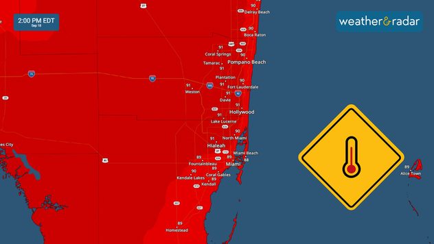
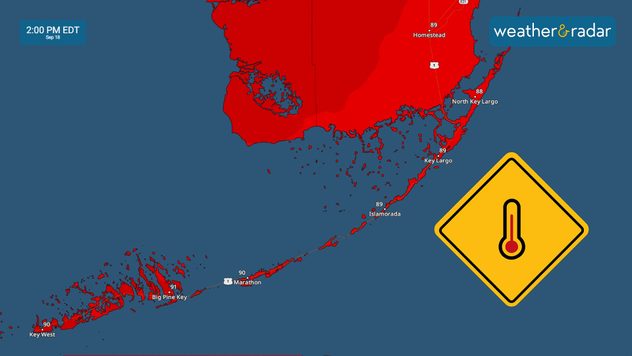
It´s been quite a year for South Florida. Today is yet another scorching day in a year already marked by above-normal heat. Our forecast temperatures for Miami shows temperatures ranging from 90 to 93 degrees, that's 1 to 4 degrees above the average for the Miami area. So far this year, there have been over 85 days when the heat index has reached at least 100º F.

Feels-like temperatures have been in the low 90s around sunrise on Wednesday and will continue to increase. Wednesday afternoon it will feel as high as 100F across much of South Florida, this includes Broward and Monroe Counties too.

Understanding feels-like temperatureread more

Make sure to limit your time ourdoors, eat light meals, stay hydrated and never leave kids, elders or pets in the car. The UV index is also high, protect your skin by using sunblock.

Irene Sans
More on the topic
Europe: Warmest June on record. Warm waters too. . . Friday, July 10, 2026
The record-breaking heatwave in June has made climate history in Western Europe.
Friday, July 10, 2026

Warm waters too

Europe: Warmest June on record
Waterspouts possible, what are they?. They can be dangerous. . . Sunday, August 9, 2026
Waterspouts weatherradar.
Sunday, August 9, 2026

They can be dangerous

Waterspouts possible, what are they?
Super Typhoon Bavi threatens Taiwan. 155 mph winds. . Weather Videos. Wednesday, July 8, 2026
The image shows an intense tropical cyclone over the western Pacific, east of Taiwan and the Philippines. The centre of the system is depicted as a light purple and white vortex with a clearly visible eye, surrounded by a ring of red and orange areas indicating the strongest wind speeds. A white arrow marks the typhoon’s predicted track towards the north-west, in the direction of Taiwan. To the west of the storm lie the Philippines, with the cities of Manila and Cebu; to the north of these lies Taiwan, with Taipei. Further west, the Chinese coast, including Hong Kong, and parts of Vietnam can be seen. The coloured wind map shows predominantly green areas outside the storm’s core, indicating significantly weaker winds. White streamlines illustrate the typhoon’s anti-clockwise circulation in the Northern Hemisphere. The highest wind speeds are concentrated around the eye of the cyclone.
Weather VideosWednesday, July 8, 2026

155 mph winds

Super Typhoon Bavi threatens Taiwan
All weather news
This might also interest you
20 days of at least 100°F. Southern Plains. . . Thursday, August 20, 2026
Thursday, August 20, 2026

Southern Plains

20 days of at least 100°F
Gravity wave clouds explained. The ideal conditions. . . Saturday, August 22, 2026
Saturday, August 22, 2026

The ideal conditions

Gravity wave clouds explained
Tornado producer brings fall refresh. Northeast low. . . Friday, August 21, 2026
Friday, August 21, 2026

Northeast low

Tornado producer brings fall refresh
All articles
Weather & Radar

Weather & Radar is also available on

Google Play StoreApp Store

Company

Contact us Privacy policy Legal info Accessibility statement

Services

Uploader

Socials

instagramfacebookthreadslinkList