Home
Weather New York
WeatherRadar
RainRadar
TemperatureRadar
WindRadar
LightningRadar
Weather News
Editor's Pick
Discover the app
Weather widget
Contact us
Apps
Career
    Home / Editor's Pick /

    Extreme temperatures take over! Record heat from the South to East

03:44 PM
May 7, 2024

Extreme temps take over!
Record heat from the South to East

How are the temperatures warming in the spring? This week is a prime example of extreme and prolonged heat for the South through the East. Lots of records will be broken!

The winds are shifting and this change in winds ramps up the temperatures across Florida and much of the Southeast. This change in winds is in response to that major low-pressure system causing severe weather across the Plains and on Tuesday bringing another round of severe weather to the Mississippi Valley and Lower Ohio Valley.

Wind u0026 location: How?

Winds play a big role in the temperatures. As the wind moves from the south of the southwest and travels over land, it heats. Usually, locations are the warmest than where the winds come from and farthest from the coast.

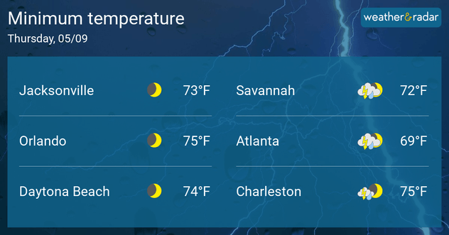
Several records will be broken starting Tuesday and continuing through the weekend. The peak of the extreme heat will happen on Wednesday and Thursday mornings with very warm low temperatures near or breaking records. Jacksonville and Sanford, Fla., will hit 93 degrees on Tuesday afternoon. But on Wednesday morning the record warm lows will be spread abundantly between Louisiana through the Southeast and the mid-Atlantic, including several locations along the Appalachian Mountains. Lows will range between the upper-60s to the mid-70s.

Many records will be broken in the morning, as lows will stay warm.

The southwest winds swinging across Florida will push the temperatures across the eastern half of Florida through Georgia and the Carolinas to the upper 80s to the mid-90s, the higher range over eastern Florida. Central Florida will be coming very close to record, or breaking records, on Wednesday and Thursday, many records were established in 2009. From Lakeland through Orlando temperatures are forecast to reach the upper 90s, but with the humidity, these temperatures could feel as if they were around 105F.

Check the temperature in our TemperatureRadar

The interesting fact is that spring is warming at a fast pace across much of the U.S. Not only have temperatures warmed between 2 and 4 degrees warmer in the Spring (and more than 5 degrees across the Southwest) but there are a much higher number of days with above average temperatures in the spring for most cities. Orlando has recorded more than 14 days with above-average temperatures since 1970 in the spring.

As summer quickly approaches, and the above-average temperature months stuck up, make sure to follow safety guidelines to stay safe when hot temperatures are happening in your city. The heat not only affects us, but also our pockets, activities, and overall health. Keep a close eye on those more vulnerable to extreme heat like the kids, elderly, and those with health problems.

Irene Sans
More on the topic
Meteorological vs astronomical autumn. Season start date. . . Tuesday, September 1, 2026
Tuesday, September 1, 2026

Season start date

Meteorological vs astronomical autumn
Hurricane Polo remains dangerous. Active Pacific. . . Thursday, September 24, 2026
Thursday, September 24, 2026

Active Pacific

Hurricane Polo remains dangerous
Hurricane parade in the Pacific. Karina is very strong. . Weather Videos. Tuesday, September 1, 2026
WindRadar for Friday, showing the three hurricanes – Lowell, Karina and Maria – over the Pacific.
Weather VideosTuesday, September 1, 2026

Karina is very strong

Hurricane parade in the Pacific
All weather news
This might also interest you
Hawaii's busy hurricane season. Nolo could set record. . . Thursday, September 24, 2026
Hawaii troubles
Thursday, September 24, 2026

Nolo could set record

Hawaii's busy hurricane season
More signs of autumn. Cooler days ahead. . . Friday, September 18, 2026
Friday, September 18, 2026

Cooler days ahead

More signs of autumn
Double September's rain in 72 hours. New Mexico. . . Tuesday, September 22, 2026
Tuesday, September 22, 2026

New Mexico

Double September's rain in 72 hours
All articles
Weather & Radar

Weather & Radar is also available on

Google Play StoreApp Store

Company

Contact us Privacy policy Legal info Accessibility statement

Services

Uploader

Socials

instagramfacebookthreadslinkList