Home
Weather New York
WeatherRadar
RainRadar
TemperatureRadar
WindRadar
LightningRadar
Weather News
Editor's Pick
Discover the app
Weather widget
Contact us
Apps
Career
    Home / Weather News /

    Flood threat grows in Pacific Northwest

03:05 PM
December 10, 2025

Atmospheric River
Flood threat grows in Pacific Northwest

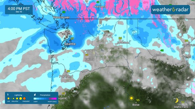
The flood threat is growing across portions of Washington and northern Oregon as an atmospheric river brings heavy rain and mountain snow to the region.

A prolonged atmospheric river will continue to bring the threat of flooding through the end of the week across portions of the Pacific Northwest. A narrow, but intense, plume of moisture originating from Hawaii is surging through the region. This comes after two days of steady rainfall for parts of Washington and Oregon.

Widespread urban and river flooding is expected, with considerable impacts along the Skagit and Snohomish Rivers. Flooding is also expected from the foothills of the Cascades to Puget Sound. Seattle, Tacoma and Olympia, Wash., are at risk today. The risk of flooding also stretches into northern Idaho and western Montana.

The WeatherRadar shows an atmospheric river impacting the Pacific Northwest.

Widespread rain totals of 2-3 inches are expected through the end of the week, with some spots picking up 5 inches or more locally. Snowmelt may also contribute to flooding today into the end of the week. Areas of steep terrain will remain at risk for landslides. While the rain will start to taper off by Friday, rising rivers will remain an issue even after the rain ends.

Mary Mays
More on the topic
Super Typhoon Bavi threatens Taiwan. 155 mph winds. . Weather Videos. Wednesday, July 8, 2026
The image shows an intense tropical cyclone over the western Pacific, east of Taiwan and the Philippines. The centre of the system is depicted as a light purple and white vortex with a clearly visible eye, surrounded by a ring of red and orange areas indicating the strongest wind speeds. A white arrow marks the typhoon’s predicted track towards the north-west, in the direction of Taiwan. To the west of the storm lie the Philippines, with the cities of Manila and Cebu; to the north of these lies Taiwan, with Taipei. Further west, the Chinese coast, including Hong Kong, and parts of Vietnam can be seen. The coloured wind map shows predominantly green areas outside the storm’s core, indicating significantly weaker winds. White streamlines illustrate the typhoon’s anti-clockwise circulation in the Northern Hemisphere. The highest wind speeds are concentrated around the eye of the cyclone.
Weather VideosWednesday, July 8, 2026

155 mph winds

Super Typhoon Bavi threatens Taiwan
High pressure & extreme heat. Why & how does it work?. . . Sunday, July 12, 2026
Sunday, July 12, 2026

Why & how does it work?

High pressure & extreme heat
Super Typhoon Near the Philippines. Gusts up to 155. . . Tuesday, June 23, 2026
Tuesday, June 23, 2026

Gusts up to 155

Super Typhoon Near the Philippines
All weather news
This might also interest you
Northern New England storms. Rare severe threat. . . Tuesday, July 14, 2026
Tuesday, July 14, 2026

Rare severe threat

Northern New England storms
Area to watch this weekend. Tropical trouble?. . . Wednesday, July 15, 2026
An area of low pressure is expected to develop this weekend off Florida's Big Bend. The question is: will this mean tropical trouble for the Southeast?
Wednesday, July 15, 2026

Tropical trouble?

Area to watch this weekend
Desert Southwest heat for the Dakotas. 1,000-mile difference. . . Monday, July 13, 2026
Monday, July 13, 2026

1,000-mile difference

Desert Southwest heat for the Dakotas
All articles
Weather & Radar

Weather & Radar is also available on

Google Play StoreApp Store

Company

Contact us Privacy policy Legal info Accessibility statement

Services

Uploader

Socials

instagramfacebookthreadslinkList