Home
Weather New York
WeatherRadar
RainRadar
TemperatureRadar
WindRadar
LightningRadar
Weather News
Editor's Pick
Discover the app
Weather widget
Contact us
Apps
Career
    Home / Editor's Pick /

    Flooding risk lingers for days - Texas at a big risk for hail, winds

02:17 PM
May 28, 2024

Flooding risk for days
Texas at a big risk for hail, winds

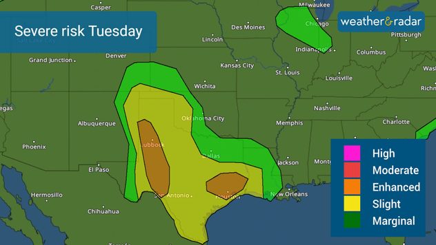
Texas has 254 counties and 247 are under severe threat on Tuesday. There is a slight risk of severe storms with a big chunk of the state under a higher risk, enhanced, level 3 of 5, in the severity scale for Tuesday, and a lingering flood threat throughout the rest of the week. Let’s look at what’s happening.

Large hail and damaging winds are the main threats on Tuesday.

There is a low-pressure system located over west Texas with a warm front traveling from the south across the Lone Star State. There is quite a light show with thousands of lightning strikes across Northeast Texas this morning. Over half a million people are dealing with power outages this morning.

From these storms, there will be an outflow boundary that will erupt from this main line of thunderstorms and move southward. Expect severe storms to affect Central and Southeast Texas in the afternoon into the evening. The biggest threats will be damaging winds of at least 80 mph and very large hail. We can’t rule out a few tornadoes.

Flood risk lingers for days.

As the low-pressure system fizzles, there will be a stationary front that will park across Texas, increasing the flood threat and allowing the rain to continue for days. For Tuesday, the moderate risk for flooding falls west over the Metroplex and includes Waco and Killeen and to the northwest of the Metroplex along The Brazos River.

A slight risk of flooding is present all around the moderate risk, and it includes Houston and surroundings, San Antonio, San Angelo, southern Oklahoma, through Dallas. Overall, there could be between 4 to 6 inches of rain, with some isolated spots receiving over 8 inches. Please heed the authorities’ orders and do not try to cross flood waters.

We are closely monitoring the situation in Texas and will continue to bring you updates throughout the day. Please check back often for updates.

Irene Sans
More on the topic
Meteorological summer is here!. Bye, spring!. . . Monday, June 1, 2026
Monday, June 1, 2026

Bye, spring!

Meteorological summer is here!
Record-breaking heatwave in Europe. Hotter than most of U.S.. . . Thursday, June 25, 2026
Thursday, June 25, 2026

Hotter than most of U.S.

Record-breaking heatwave in Europe
Rip currents & safety tips. As more head to the coast. . . Saturday, July 25, 2026
rip current
Saturday, July 25, 2026

As more head to the coast

Rip currents & safety tips
All weather news
This might also interest you
Heat indices soaring. High humidity. . . Saturday, July 25, 2026
Saturday, July 25, 2026

High humidity

Heat indices soaring
Lopsided Bertha moves west. Who sees the impacts. . . Thursday, July 23, 2026
Thursday, July 23, 2026

Who sees the impacts

Lopsided Bertha moves west
Southwest heat disrupts daily flow. Closures & delays. . . Monday, July 27, 2026
Monday, July 27, 2026

Closures & delays

Southwest heat disrupts daily flow
All articles
Weather & Radar

Weather & Radar is also available on

Google Play StoreApp Store

Company

Contact us Privacy policy Legal info Accessibility statement

Services

Uploader

Socials

instagramfacebookthreadslinkList