Home
Weather New York
WeatherRadar
RainRadar
TemperatureRadar
WindRadar
LightningRadar
Weather News
Editor's Pick
Discover the app
Weather widget
Contact us
Apps
Career
    Home / Editor's Pick /

    Florida’s heat: Weak front divides the state in two, hot everywhere

03:01 PM
May 29, 2024

Florida’s heat weak front
Divides the state in two, hot everywhere

It’s been hot, but now it is record-hot across much of Florida. Temperatures on Wednesday afternoon will be close to the triple digits.

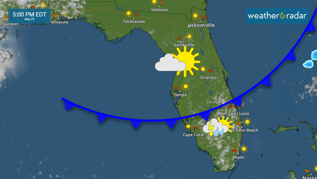
You’d be surprised to know that there is a very weak cold front that will push through just south of Central Florida, and there will be a stark difference between the northern half and southern half of the Peninsula. The main difference will be that the southern half, from around the Treasure Coast, Lake Okeechobee southward will have higher rain chances and the north will remain mostly dry. Check out our WeatherRadar to time the showers and storms.

Weak cold front travels southward, increasing the rain chances.
A weak cold front travels southward, increasing the rain chances.

The dry air will not only limit rain chances for Central and North Florida, but it will not allow for much cooling, since the showers are what usually cool us during this time of the year. Record temperatures are likely for Tampa, Lakeland, Fla., Leesburg, and Port Charlotte. Temperatures in these locations will reach 95 and above.

The proximity of the weakening cold front and the sea breezes will likely fire up a few thunderstorms across South Florida, some of them could be isolated from strong to severe, just like they were on Tuesday afternoon. Temperatures will also be hot and feel hotter courtesy of the humidity. The high in Miami could come close to the record of 94 established in 1951.

Make sure to take frequent breaks if you are working or doing activities outdoors and to stay hydrated throughout the day. Do not wait until you are thirsty to drink water, you could be already dehydrated. Dress in light colors and light fabrics and eat light meals to help your body deal with the heat a bit easier.

Irene Sans
More on the topic
Hawaii's second 2026 hurricane impact. Hurricane Lowell. . . Tuesday, September 8, 2026
Tuesday, September 8, 2026

Hurricane Lowell

Hawaii's second 2026 hurricane impact
Record ocean heat halting hurricanes. Strong El Niño influence. . . Sunday, September 13, 2026
A weather map shows a calm Atlantic Ocean with no hurricanes, alongside a picture of the sea.
Sunday, September 13, 2026

Strong El Niño influence

Record ocean heat halting hurricanes
Hurricane parade in the Pacific. Karina is very strong. . Weather Videos. Tuesday, September 1, 2026
WindRadar for Friday, showing the three hurricanes – Lowell, Karina and Maria – over the Pacific.
Weather VideosTuesday, September 1, 2026

Karina is very strong

Hurricane parade in the Pacific
All weather news
This might also interest you
Isaias landfall dangers. Surge, outages, flooding. . . Friday, October 9, 2026
Friday, October 9, 2026

Surge, outages, flooding

Isaias landfall dangers
Soggy end to the weekend for some. Remnants of Isaias. . . Sunday, October 11, 2026
While Isaias may have made landfall near Destin, Fla., Friday night, the hurricane's remnants will bring a soggy end to the weekend hundreds of miles away from the point of landfall.
Sunday, October 11, 2026

Remnants of Isaias

Soggy end to the weekend for some
Isaias post-landfall impacts. Southeast soaker. . . Saturday, October 10, 2026
Southeast impacts of Isaias
Saturday, October 10, 2026

Southeast soaker

Isaias post-landfall impacts
All articles
Weather & Radar

Weather & Radar is also available on

Google Play StoreApp Store

Company

Contact us Privacy policy Legal info Accessibility statement

Services

Uploader

Socials

instagramfacebookthreadslinkList