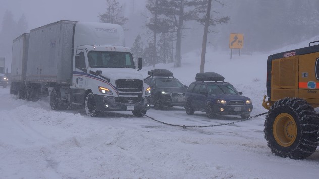
Home / Editor's Pick /

Friday's live blog: Travel nightmare, major roads closed

10:05 PM
March 1, 2024

Friday's live blog
Travel nightmare, major roads closed

Recommended external content from YouTube

We need your consent to show content from YouTube. You can withdraw your consent at any time.

I agree that content from YouTube will be displayed to me.

Settings for external content

Privacy policy

A massive storm will likely bring historic snowfall over the Sierra Nevada mountains. Some areas are forecast to receive close to 12 feet of snow, while lower elevations will be dealing with rain which may lead to flooding. Another big impact will be the winds. Gusts could approach 140 mph along the higher peaks, and 70 mph across lower elevations. Power outages are possible. Traveling is not recommended as conditions will be dangerous and life-threatening.

6:00 p.m. ET/3:00 p.m. PT

Wind gusts in excess of 100 mph have been recorded along ridgetops in the Sierra Nevada. As heavy snow and wind continues, travel will be dangerous and power outages will be possible.

5:00 p.m. ET/2:00 p.m. PT

Worsening weather through the rest of Friday into Saturday. SierraWorsening weather through the rest of Friday into Saturday.sierra snowstormWorsening weather through the rest of Friday into Saturday. SierraWorsening weather through the rest of Friday into Saturday. Sierra
1/5

4:30 p.m. ET/1:30 p.m. PT

Our weather reporter, Jonathan Petramala, is reporting from Donner Pass, California, and will continue to follow this storm closely through the weekend. Check out his latest report.

3:30 p.m. ET/12:30 p.m. PT

The system affecting the West will continue to pound the Sierras. On top of the almost 2 feet that fell overnight across some areas, there could be another 5-6 feet falling through Saturday afternoon. Another 2-4 feet could accumulate on Sunday and Monday.

It is important to point out that snowfall will start to happen across lower elevations at around 1,000 to 1,500 feet this Friday or Saturday early. Some locals say that this storm is unique as 12 feet of snow from just one system is a lot.

Local residents can expect power outages through the weekend.

2:45 p.m. ET/11:45 a.m. PT

1:40 p.m. ET/10:40 a.m. PT

Meteorologist Becca Parker will be live at 3 p.m. ET / 12 p.m. PT to discuss the worsening weather conditions expected for the California mountains on Friday and Saturday.

Watch her live, set your alarms.

12:40 p.m. ET/9:40 a.m. PT

Snowpack continues to grow!

11:40 a.m. ET/8:40 a.m. PT

Heavy snow has been falling overnight on the Sierras. This storm will bring a multi-day risk for blizzards, which will cause whiteout conditions along the mountains, even across elevations of 2000 feet. This will not the right weekend to travel to or from the mountains.

Across the backcountry over the central Sierra, there is a high to extreme risk of avalanches.

Irene Sans
Weather & Radar USA editorial team
More on the topic
Saturday, April 19, 2025

Your weather - Your shots

Sunrise views and misty mornings
easter
Sunday, April 20, 2025

A chance to reflect

Happy Easter to all
Sunday, April 13, 2025

Your weather - Your shots

An international spring collection
All weather news
This might also interest you
Live storm chase in the Deep South - May 2025.
Tuesday, May 20, 2025

Tornado watch active

LIVE: Deep South storm chase
Saturday, May 24, 2025

Learn about mammatus

These clouds can mean severe weather
Thursday, May 22, 2025

Breakfast Brief

Wet in the Northeast, hot in Texas
All articles
Weather & Radar

www.weatherandradar.com

instagramfacebookthreadsContact uslinkList
Privacy policy | Legal info