Home
Weather New York
WeatherRadar
RainRadar
TemperatureRadar
WindRadar
LightningRadar
Weather News
Editor's Pick
Discover the app
Weather widget
Contact us
Apps
Career
    Home / Editor's Pick /

    Global consequence - El Niño is back

02:40 PM
March 24, 2026

Global consequences
El Niño is back

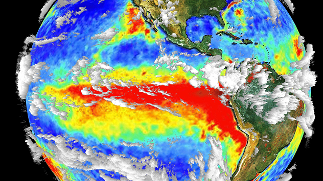
The image shows the central Pacific in a computer model. A striking feature is the ocean coloured red, which indicates very warm seawater.
Unusually warm sea water in the equatorial Pacific is a characteristic feature of El Niño. - © dpa

Current forecasts suggest that the El Niño climate phenomenon is set to develop in the Pacific in the coming months, after nearly two years of mild La Niña conditions.

This shift could have consequences for the weather worldwide.

How El Niño affects the weather

"El Niño–Southern Oscillation (ENSO)" is a more or less regular cycle consisting of phases characterized by El Niño and its counterpart, La Niña.

During El Niño, sea surface temperatures in the equatorial Pacific are significantly higher than average, whilst during La Niña they are significantly lower. Furthermore, during El Niño, the normally steady trade winds virtually come to a standstill.

The upcoming El Niño phase has a particular impact on the weather in the Pacific region: the South American Pacific Coast typically experiences much higher rainfall, whilst Southeast Asia and the Amazon region are drier than usual.

Changes in atmospheric circulation can also have an impact on regions far away, including southern and eastern Africa. In the North Atlantic, El Niño reduces the activity of tropical storms and hurricanes while severe weather across the U.S. southern tier is often more frequent than usual.

Will 2026 be the warmest year on record?

During El Niño, the exceptionally warm Pacific releases an enormous amount of energy into the atmosphere, which can further increase the global average temperature. Given the history of La Niña and the ongoing effects of climate change, it is not unlikely that 2026 will be the warmest year on record globally.

Current temperatures worldwideTemperatureRadar
Weather & Radar USA editorial team
More on the topic
Super Typhoon Near the Philippines. Gusts up to 155. . . Tuesday, June 23, 2026
Tuesday, June 23, 2026

Gusts up to 155

Super Typhoon Near the Philippines
Waterspouts possible, what are they?. They can be dangerous. . . Sunday, August 9, 2026
Waterspouts weatherradar.
Sunday, August 9, 2026

They can be dangerous

Waterspouts possible, what are they?
Super Typhoon Bavi threatens Taiwan. 155 mph winds. . Weather Videos. Wednesday, July 8, 2026
The image shows an intense tropical cyclone over the western Pacific, east of Taiwan and the Philippines. The centre of the system is depicted as a light purple and white vortex with a clearly visible eye, surrounded by a ring of red and orange areas indicating the strongest wind speeds. A white arrow marks the typhoon’s predicted track towards the north-west, in the direction of Taiwan. To the west of the storm lie the Philippines, with the cities of Manila and Cebu; to the north of these lies Taiwan, with Taipei. Further west, the Chinese coast, including Hong Kong, and parts of Vietnam can be seen. The coloured wind map shows predominantly green areas outside the storm’s core, indicating significantly weaker winds. White streamlines illustrate the typhoon’s anti-clockwise circulation in the Northern Hemisphere. The highest wind speeds are concentrated around the eye of the cyclone.
Weather VideosWednesday, July 8, 2026

155 mph winds

Super Typhoon Bavi threatens Taiwan
All weather news
This might also interest you
Rare hurricane impacts possible. Big Island, Hawaii. . . Thursday, August 13, 2026
Thursday, August 13, 2026

Big Island, Hawaii

Rare hurricane impacts possible
Temperatures rise 20 degrees at 2 am?. What is a heat burst?. . . Sunday, August 16, 2026
Heat burst in Nebraska
Sunday, August 16, 2026

What is a heat burst?

Temperatures rise 20 degrees at 2 am?
Days of record nighttime heat. Feeling tropical. . . Monday, August 17, 2026
Monday, August 17, 2026

Feeling tropical

Days of record nighttime heat
All articles
Weather & Radar

Weather & Radar is also available on

Google Play StoreApp Store

Company

Contact us Privacy policy Legal info Accessibility statement

Services

Uploader

Socials

instagramfacebookthreadslinkList