Home
Weather New York
WeatherRadar
RainRadar
TemperatureRadar
WindRadar
LightningRadar
Weather News
Editor's Pick
Discover the app
Weather widget
Contact us
Apps
Career
    Home / Weather News /

    WindRadar focus - Frontal passage triggers storms, chill

03:59 PM
May 5, 2026

WindRadar focus
Frontal passage triggers storms, chill

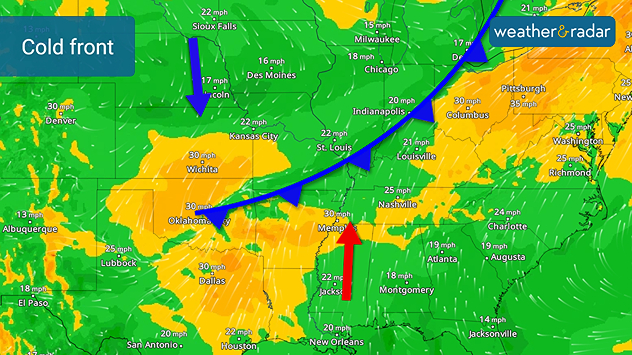
Many are dressing for a different season across the Plains today after a cold front left behind temperatures 20 to 30 degrees cooler than Monday's highs. This same gusty front is triggering severe storms today and overnight in addition to more temperature dips.

The WindRadar shows the cold front bringing busy weather into the central U.S. today. See the wind directions meeting? This is the convergence zone - the boundary between two different air masses. This clash is triggering severe weather today and through the overnight.

Cold front divides two air masses. One colder to the north, and one warmer to the south.
WindRadar: Cold front divides two air masses. One colder to the north, and one warmer to the south.

Those with severe storms in the forecast today will notice warm, humid winds out of the south. Those with colder temperatures in their Tuesday forecast have the northerly and cooler air flow.

The TemperatureRadar confirms the difference in air masses.

Becca Parker
More on the topic
Longest day of the year is here. Summer solstice. . . Sunday, June 21, 2026
Sunday, June 21, 2026

Summer solstice

Longest day of the year is here
Waterspouts possible, what are they?. They can be dangerous. . . Saturday, July 11, 2026
Waterspouts weatherradar.
Saturday, July 11, 2026

They can be dangerous

Waterspouts possible, what are they?
Rip currents & safety tips. As more head to the coast. . . Saturday, July 25, 2026
rip current
Saturday, July 25, 2026

As more head to the coast

Rip currents & safety tips
All weather news
This might also interest you
Southwest heat disrupts daily flow. Closures & delays. . . Monday, July 27, 2026
Monday, July 27, 2026

Closures & delays

Southwest heat disrupts daily flow
Low pressure brings wet weekend. Soggy East. . . Friday, July 31, 2026
Friday, July 31, 2026

Soggy East

Low pressure brings wet weekend
Three common misperceptions. Hurricane season. . . Sunday, August 2, 2026
Hurricane Ian (2022) satellite imagery before SWFL landfall.
Sunday, August 2, 2026

Hurricane season

Three common misperceptions
All articles
Weather & Radar

Weather & Radar is also available on

Google Play StoreApp Store

Company

Contact us Privacy policy Legal info Accessibility statement

Services

Uploader

Socials

instagramfacebookthreadslinkList